

|
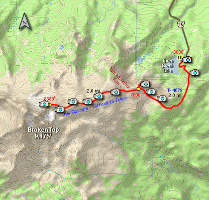
THE FOLLOWING MAP IS NOT TO BE USED FOR NAVIGATIONAL PURPOSES.
|
Length: 8 miles round trip
Elevation Change: 1800' cummulative elevation gain
Season: Mid-Summer thru Early Fall
Difficulty: Challenging
Permit: NW Forest Pass Required
GPS: N44 6.084, W121 37.35
Latitude: 44.1014
Longitude: -121.6225
Features:
This hike is only snow free for a brief period
of time between mid summer and early fall. Yet,
it is one of the most rewarding adventures in
the beautiful Three Sister's Wilderness Area.
The hike gains about 1800' in elevation, and
takes you up from a fairly dense pine
forest into a sub alpine region across the
very top of Tam McArthur Rim and to the
very northeastern flank of Broken Top Mountain.
The trail begins climbing immediately from
the designated trailhead through a weathered
stand of a ancient pine forest. You are
presented with fabulous views almost immediately.
And it just keeps getting better as you climb.
If you only climb to the viewpoint on
Tam McArthur Rim you will be rewarded greatly
for your effort. The rest of this hike
should be attempted only by those hikers
with alot of experience and who are in
excellent physical condition.
The trail, if you want to call it that,
from the overlook on Tam McArthur Rim to
the northeastern flank of Broken Top
Mountain is obscure and very difficult at
times to follow. Depending on the season
the trail is often covered by snow.
Only attempt this
hike if you are a very experienced hiker
and are in excellent physical condition.
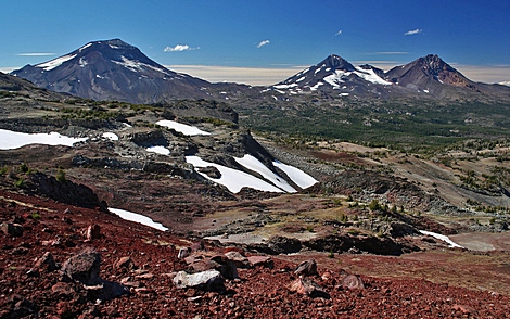
Three Sisters from Tam McArthur Ridge
|
|
How to get there:
From Sisters, Oregon drive 17.0 miles south on Forest Road 16 (Elm Street in Sisters) to the Three Creeks Campground.
|
|
A Virtual Hike of the Three Sisters Wilderness Area


|
|
