

|
THE FOLLOWING MAP IS NOT TO BE USED FOR NAVIGATIONAL PURPOSES.
|
Length: 12.4 mile RT
Elevation Change: 3100' elevation gain
Season: Summer thru Fall
Difficulty: Difficult
Permit: NWF Pass Required
GPS:
Latitude: 44.7429
Longitude: -121.8894
Features:
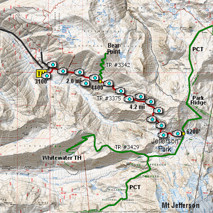
Here is another outstanding hike with incredible payoff.
From the trail head you head east on Trail #3375,
which is one of the three main trails that take
a hiker to Jefferson Park at the base of Mt. Jefferson.
The first two miles the trail climbs through
a dense forest, crossing several small streams along the way.
You then come to the junction of Trail #3342, which leads
to the left and to the summit of Bear Point. You, however,
keep hiking straight ahead. The trail wanders through very
rugged terrain, and because of water run-off there are a
number of places where you need to watch your step because
of the large rocks left in the trail from the erosion.
The trail becomes a lot steeper now, as it begins to work
its way up into the Jefferson Park Basin. From time to time
you will catch some glimpses of Mt. Jefferson and behind you
the Breitenbush River Valley. To the southwest you can see
Triangulation Peak.
About 4 miles into the hike, you will not only be more out
in the open, and in season surrounded by wildflower, but
you will come upon the only large tarn along the trail.
The trail continues to climb for another half mile or so,
then passes over a ridge and you begin to actually desend
into the Jefferson Park Basin. At times the rocky trail
gets very steep, but only for a short distance. Most of
the trail from here on out is in great shape.
Finally, you will come to the junction of the Pacific Crest
Trail. At this point you are in Jefferson Park, so just
wander where you will and enjoy all the lakes, tarns, flowers,
and mosquitos that your heart desires..... did I say mosquitos???
Oh dear..... Enjoy!

Wildflowers along the trail to Jefferson Park
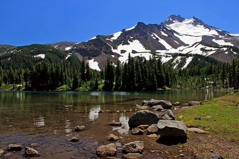
Tarn along the trail to Jefferson Park
|
How to get there:
From the junction of Forest Road 46 and Oregon state highway 22 at the west end of
the community of Detroit Lake, travel north on FR 46 for approximately 11.6 miles
to the junction with Forest Road 4685. Turn onto FR 4685, which will immediately
take you over the North Ford of the Breitenbush River, then follow the Breitenbush
River southeast. Continue on FR 4685 for about 4.7 miles and you will come to a
large parking area on your right, which is the trail head for this hike.
|
|
|
A Virtual Hike of the Mount Jefferson Wilderness Area


|
|
