

|
THE FOLLOWING MAP IS NOT TO BE USED FOR NAVIGATIONAL PURPOSES.
|
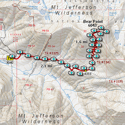
Length: 7.4 mi RT
Elevation Change: 3030' cumulative elevation gain
Season: Summer thru Fall
Difficulty: Difficult - very steep
Permit: NWF Pass not required
GPS: N44 44.574 W121 53.364
Latitude: 44.7429
Longitude: -121.8894
Features:
Here is an outstanding hike with incredible payoff.
From the trail head you head east on Trail #3375,
which is one of the three main trails that take
a hiker to Jefferson Park at the base of Mt. Jefferson.
However to climb Bear Point, you will only follow
this trail for about 2 miles, as it climbs through
a dense forest, crossing several small streams along the way.
When you come to the junction of Trail #3342, bear
left onto this trail and after crossing a small stream
you will begin the arduous climb up to the summit of
Bear Point.
As the trail climbs over 1700 feet in about a mile
and a half, you will be treated to spectacular views
of Mt. Jefferson and other peaks to the south.
When you reach the summit of Bear Point, you will
also be able to see Mt. Hood to the north.
This hike is not for faint hearted. It is steep.
Take plenty of water, and rest often.
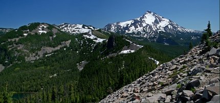
View of Mt. Jefferson from Bear Point
|
How to get there:
From the junction of Forest Road 46 and Oregon state highway 22 at the west end of
the community of Detroit Lake, travel north on FR 46 for approximately 11.6 miles
to the junction with Forest Road 4685. Turn onto FR 4685, which will immediately
take you over the North Ford of the Breitenbush River, then follow the Breitenbush
River southeast. Continue on FR 4685 for about 4.7 miles and you will come to a
large parking area on your right, which is the trail head for this hike.
|
|
|
A Virtual Hike of the Mount Jefferson Wilderness Area


|
|
