Length: 12 miles round trip
Elevation Change: 1800' elevation gain
Season: Summer thru Fall
Difficulty: Challenging
Permit: NW Forest Pass Required
Features:
This is possibly the most worthwhile hiking
destination in the Mt Jefferson Wilderness
area. The trail is a gentle steady climb
and is in excellent condition as it is well
maintained.
The hike gains about 1800' in elevation, and
takes you up from a fairly dense large growth
forest into the sub alpine region on the north
flank of beautiful Mt. Jefferson.
Depending on the season in which you take the
hike, the floral displays can be magnificent.
The last two weeks in July are usually the
best time for flowers and minimal snow cover.
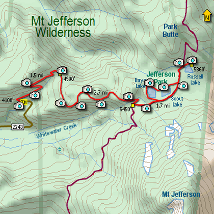
The trial climbs the Sentinel Hills where after
a mile and a half it intersects the trail from
Triangulation Peak. Bearing to the right the
trail continues to climb and the trees for the
most part become significantly smaller and less
dense.
In about another mile you will come around a gentle
bend in the trail when all of a sudden the earth
drops away from you on the right and Mt Jefferson
leaps into your view. This is a truly fantastic
scene and worth the whole trip alone.
As you continue you will come to the only
challenging creek crossing. Depending on the
season, it can be difficult, but most of the
time it is no serious problem.
Shortly after crossing the creek, you will come
to the intersection with the Pacific Crest Trail.
Now bear left onto the PCT and follow it to
Jefferson Park.
As you come out onto the level plain of Jefferson
Park, you will notice a myriad of trails leading
to various lakes and ponds and camping sites.
But I would continue on to the northern most of
the major lakes, Russell Lake and devour the views
and in season the floral displays around the lake.
Then back track to Scout Lake and Bays Lake. You
can follow a trail along the north side of both of
these lakes then circle around the west side of Bays
Lake, returning to the PCT and back to your vehicle.
With all the water you can be sure of insects, so
come prepared. Nevertheless, it is absolutely worth
the trip no matter a few pests..... ENJOY!!
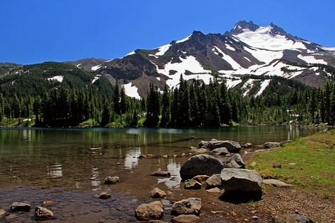
Looking across Scout Lake toward Mt. Jefferson
|