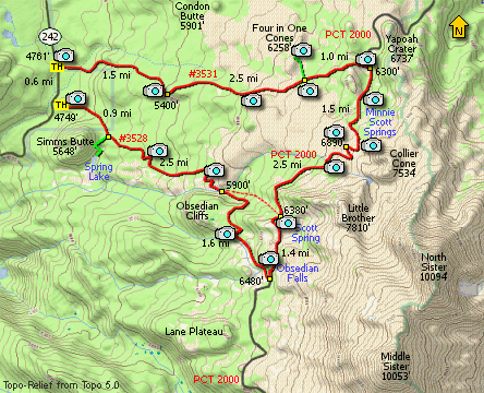
Length: 16 miles round trip
Elevation Change: c. 2800' cumulative elevation gain
Season: Summer thru Fall
Difficulty: Difficult
Permit: NW Forest Pass Required
Please note that you need a Special Use Permit to hike this loop or anywhere in the Obsidian
Cliffs area. Contact the local Forest Ranger Station for such a permit.
Features:
First, let me say, that considering the configuration
of this hike, one does not have to do the entire
loop to enjoy a fabulous hiking experience to any
part of this area.
I hiked the loop clockwise and did a couple side
trips, such as the 4 in one Cones. The trail is
remarkably gentle, just long if you do the whole
thing. I've been to this area a couple of times,
and the first time I only went to Opie Dilldock Pass.
I can guarantee you a fabulous hike if you only go
this far.
With the exception of a brief view point at about
1.5 miles, the first 3 miles of this hike is
entirely in a dense forest. Not until about 3 miles
does the trail break out due to the extensive lava
flows. Even then, the trail is in and out the
forest.
At about 4 miles the trail is out in the open
crossing an extensive cinder field and the cutoff
trail to the top of 4 in One Cones is clearly marked.
This side trip is definitely worth it if you have
the time. Not only are you afforded remarkable
views of the North and Middle Sisters Mountains,
but looking north you can see Mt Washington, Three
Fingered Jack, Mt Jefferson, and even Mt Hood.
The next mile is a bit steeper and the trail then
connects to the Pacific Crest Trail in a nice
meadow area. Depending on the time of year you
get there, flowers can be plentiful. I imagine
the flying insects can be too.
Heading south on the PCT the trail continues to
climb. Soon the trail passes Minnie Scott Springs.
This water source appears to be year round. The
trail climbs through a short switchback then heads
toward the base of Collier Cone.
A number of paths can be seen that will take you
up Collier Cone, but the main path is after Opie
Dilldock Pass. The loop trail around Collier Cone
intersects the PCT just a few feet apart and are
marked with rather substantial cairns.
Then the trail does a surprising steep drop through
a series of short switchbacks in order to cross a
stream at what is called Sawyer Bar. This crossing
can be difficult depending on what time of year
you try to cross it.
The trail continues to loose elevation for the next
mile or so before climbing back up the junction
of the Glacier Way cutoff trail. At this junction,
you can follow a user trail up the stream toward the
Middle Sister Mountain into a beautiful valley
overflowing in wildflowers if you get there in late July.
Whether you stay on the PCT of follow the user trail,
you will end up at the same place in about a half mile.
At that common destination you will be standing on a
literal mountain of obsidian. More obsidian that you
can imagine. Truly a marvel of nature. Be sure to
treat this area with great respect.
Shortly after the trail comes to a couple of small
ponds. And just beyond the ponds are springs of
clear cold water that just come up out of the earth.
And shortly after this you will come to Obsidian Falls
as the trail begins to descend to the junction that you
will need to complete the loop.
At the junction bear right onto Trail #3528, the
Obsidian Trail which will take you back to the
highway where you began your trek. The trail is
mostly downhill, but there are occassions when you
climb just a bit before continuing your descent.
In a little over a mile and a half you will come
to the junction of the Glacier Way cutoff trial
that you passed earlier on the PCT. The trail
crosses the creek and climbs a bit to get over
a rather large lava flow. There will be numerous
opportunities for great photos of the Sisters
behind you as you decend, so be sure to look back
over your shoulder.
Then the trail eventually desends into the dense
forest and you will no longer have any view opportunites.
About a mile before the end of the loop you will come
to the junction of a trail to Spring Lake. When I hiked
this there was no sign to the lake, but there was a sign
and it was obviously the junction to the lake.
Another mile of forested desent and you will come to
the parking area of the Obsidian trail head. From here
you need to follow the gravel road to the main highway
and walk along the road back to your vehicle.
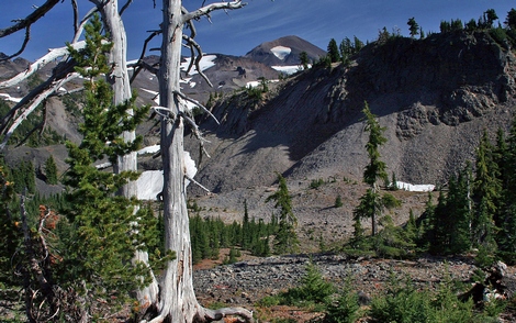
Looking up at the Middle Sisten from the Obsidian Basin trail
|