Length: 13 miles round trip
Elevation Change: 3304' elevation gain
Season: Late Summer thru Early Fall
Difficulty: Difficult
Permit: NW Forest Pass Required
Features:
This is an extraordinary hike or series of hikes in the heart of the Strawberry Mountain Wilderness.
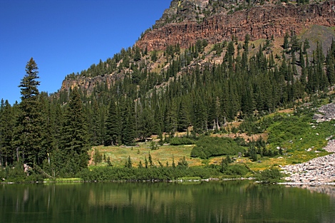
When you leave the trailhead parking area, the trail climbs steadily to Strawberry Lake. The lake
is actually damed to create a deeper and controlable watersource for the valley farmers.
Then after you come to the lake, it is another mile and a quarter to the junction which offers you
the trail over to the smaller lake Upper Strawberry Lake. Or, bear right and head to the summit of
Strawberry Mountain.
The trail climbs steadily for about a mile and a half. Then as you reach the ridgeline, it levels off a
bit and enters a large meadow area. At this point you get your first real view of the summit of
Strawberry Mountain.
The trail continues along the east side of the meadow, crosses a fine stream and then begins a short
series of switchbacks to the ridgeline of the mountain itself. It a quarter mile or so you will come
to a junction of a trail that heads south from Strawberry Mountain. Keep climbing. You will be out
in the open and the views are terrific.
After you cross the eastern face of the mountain you will come to the final ridgeline and a junction.
Bear left at this point and climb to the summit of the peak. On top the views are extensive and very
enjoyable. You can't actually see Strawberry Lake from the top because the lake is in such a deep
valley.
Upper Strawberry Lake
|


