Length: 4.5 miles round trip
Elevation Change: 1150' cummulative gain
Season: Nearly Year-round
Difficulty: Easy to Moderate
Permit: State Park Pass Required
Features:
This is one of the most popular hiking
and rock climbing areas in Oregon. After
one visit, you'll see why. This place is
just plain fantastic!
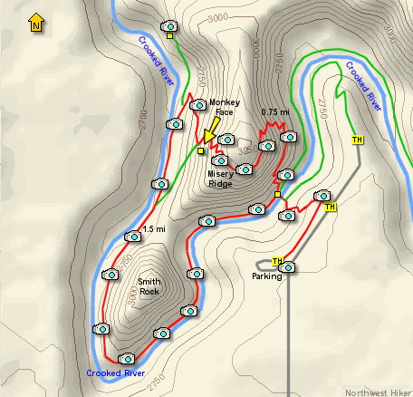
I did the hike counter-clockwise. Beginning
at the main parking area, I went east toward
the picnic area, then to the main trail. The
trail drops about 140' feet to the Crooked
River Canyon below. Then it crosses the river
via an excellent bridge.
After crossing the bridge, you have two main
choices. If you only want to get to the top
of the mountain in front of you, just keep
straight ahead, and climb. 700 feet and about
three quarters of a mile later
you will be on top.
If, on the other hand, you'd like to do a fun
loop hike, which will include getting to the
top of Misery Ridge, then bear left and follow
the trail along the Crooked River.
It is about a mile and a half to the base of
Monkey Face, which is a 400 foot verticle spire.
You then can climb through a series of well
placed switchbacks to the top of Misery Ridge.
From there you can complete your loop hike by
following the trail back down to the bridge
where you began the loop.
There are alot of wonderful things to enjoy
here at Smith Rock. Each season will offer
appropriate opportunities to satisfy your desire
for a great day in the out-of-doors. You can't
go wrong with a trip to Smith Rock State Park!
ENJOY.
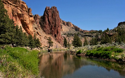
Crooked River from the Smith Rocks trail
|