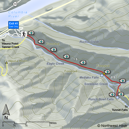
Length: 4.0 miles round trip
Elevation Change: 300' gain
Season: Year Round
Difficulty: Easy
Permit: NW Forest Pass Required
Features:
I decided to include this hike as a separate
hike even though it is on the Eagle Creek Trail. There are many
outstanding destinations on this trail, and most are covered on
Hike 37.
This hike begins at the Eagle Creek Trail head and follow the trail
for about a mile and a half. Going upstream there are not clear
markings indicating that you have arrived at the cutoff trail that
takes you to the overlook for Metlako Falls. However, after you
pass the cutoff trail, you will come to a sign on a tree indicating
the trail to the Metlako Falls overlook. Its but a short back-track,
so its no big deal.
After enjoying Metlako Falls, just return to the main Eagle Creek
Trail and continue upstream. You will soon cross a small creek,
and then come to the cutoff trail that leads down to Eagle Creek
and an area just below Punchbowl Falls. This is the way to truly
enjoy this marvelous falls.
The trail descends steeply to Eagle Creek, and if the creek is low
you can walk to a place upstream where you can view Punchbowl Falls
from creek level. If the water is high, do NOT UNDER ANY CIRCUMSTANCES
try to wade to a point where you can view the falls. High water
is too dangerous. This falls can be viewed from the Eagle Creek Trail.
Actually, after this side trip, just walk back up to the main trail, and
follow it just a bit further upstream to the overlook for Punchbowl Falls.
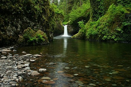 Punchbowl Falls
|
|
How to get there:
Traveling eastbound on I-84, take Exit #41. At the bottom of the ramp turn right.
Go about 1/2 mile to the end of the road. You will go past a footbridge (that takes hikers up to Wauna
Viewpoint) as the road narrows to one lane. Continue a short ways to a large parking lot; park only in
designated spaces. NW Forest Pass required.
Coming from the east, there is no westbound exit at Exit #41/Eagle Creek. You must continue on I-84 and get
off at Exit #40/Bonneville Dam, get back on the interstate and head east for one mile to Exit #41. At the
bottom of the ramp turn right. Go about 1/2 mile to the end of the road. You will go past a footbridge (that
takes hikers up to Wauna Viewpoint) as the road narrows to one lane. Continue a short ways to a large parking
lot; park only in designated spaces. NW Forest Pass required.
|