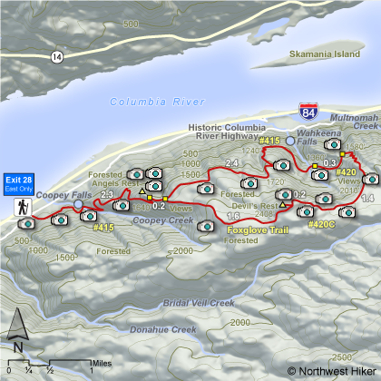
Length: 10.7 miles round trip
Elevation Change:
Trail climbs (1620')
descends (480')
and climbs (1168')
before
descending (2308')
back down past Angel's Rest and to the trail head.
Season: Spring thru Fall
Difficulty: Difficult due to steep climb and length of hike
Permit: No Pass Required
Features:
This hike is relatively steep as
it climbs through wooded areas and eventually out in the open near
the summit of Angel's Rest where there are great vistas of the
Columbia River Gorge and the surrounding mountains. After passing
the cutoff to Angel's Rest the trail continues uphill to the next
junction.
At this point you can go either left or right because you
will return to this junction after making a large loop. If you
bare left and follow trail #415, you will eventually come to
Wahkeena Springs junction. Keep to the right and follow trail
#420 to the Devil's Rest turnoff. Follow trail #420C up the
hill and along the ridge to Devil's Rest.
Enjoy the views
along the trail, because after you reach Devil's Rest, you are in a
heavily forested area with no views. Follow the Foxglove trail
past Devil's Rest back to trail #415 near Angel's Rest. Return
to the trail head on the same trail to took to this junction.
The Foxglove trail is less traveled and less maintained.
In season this entire trail route is surrounded by glorious wildflowers.
Below is a photo of the early spring flower so common on this hike; the Trillium.
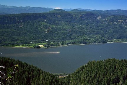 Looking north toward Mt. St. Helens
from the Devils Rest overlook
|
|
How to get there:
From the west, take I-84 east to Exit #28/Bridal Veil. Follow the road to the stop
sign and turn right onto the Historic Columbia River Hwy. The parking lot is
immediately on right. No parking pass required.
From the east, take I-84 west to Exit #35/Ainsworth State Park. Follow the
Historic Columbia River Highway for 7.1 miles to the Angel's Rest Trailhead
and the parking area is on your right. No parking pass required.
|