Search Northern Central Goat Rocks Mt Adams SE Hikes SW Hikes St Helens Hike List Return
Hike 02 Beljica Mountain and Lake Christine Main Menu
A PICTURE IS WORTH A THOUSAND WORDS MOVE MOUSE OVER MAP CAMERA ICONS TO VIEW PHOTOS - F5 TO REFRESH
MOVE MOUSE OVER TO VIEW QUICK-LINK MAP
CLICK ON ANY HIKE ICON TO JUMP TO THAT HIKE
Print Topo Map Hike Difficulty
Calculator
 
Legend Ten Essentials  

Hike Length: 3 miles round trip
Elev. Change: 1075' gain
Hike Difficulty: Challenging
Type of Hike: In and Out
Season: Summer thru Fall
Trail Numbers: #249
Trail Condition: Good
Trail Access: Excellent
Trail Signage: Good
Features: Views, Wildflowers, Lake
Pet Friendly: Yes
Useage: Heavy
Permit: NW FP NOT Required
Horses: Yes
Mtn Bikes: No

Summary:
Press CTRL + P to print. Photos do not show when you print this page. (Help)


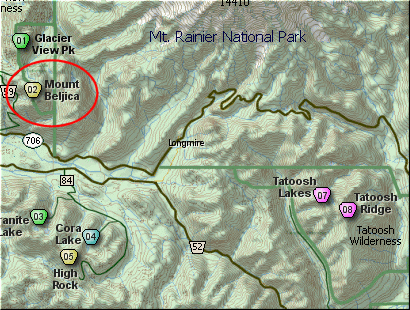
This short but very steep hike begins at the end of Forest Road 5920. The trail begins an extremely steep climb immediately. However, in a short distance it begins to become more reasonable as it switchbacks up the very steep terrain toward Lake Christine.

In about a mile you break over a saddle and come upon Lake Christine. This a beautiful little lake nestled between opposing peaks. The trail goes around the south side of the lake in what can be a very marshy area.

On the east side of the lake, the trail heads northeast on its way to Goat Lake. About a half mile later, you will come to a sign with the word TRAIL on it. The trail to Goat Lake bears right. You need to bear left and follow a user trail up very steep terrain. Soon the trail breaks out into the open and as you reach the summit of 
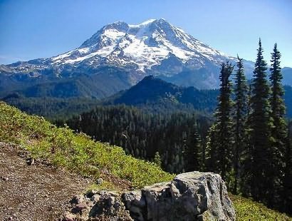
Mount Beljica, you are greeted with outstanding vistas of Mt Rainier, the Goat Rocks, Mt Adams, Mt Hood, and Mt St Helens.

In season there are lots of beautiful floral displays to add to the enjoyment of this short but challenging hike.


The following images are random samples of the wildflowers found in the Gifford Pinchot National Forest.
Mouseover image to view flower name, and click on image to jump to flower guide.

Directions:

From Puyallup, WA
From the junction of SR512 and SR161 in Puyallup to the junction of SR161 and SR7 in Elbe is about 36 miles. Then traveling east on SR161 it is about 8 miles to Ashford.

From Morton, WA
Follow SR7 north out of Morton for about 16 miles to the junction of SR161 in Elbe. Turn right onto SR161 and travel about 8 miles east to Ashford.

From Ashford travel east on highway 706 for about 3 miles. Turn left (north) onto Forest Road 59. At 4.1 miles you will pass Forest Road 5920 which goes to the trailhead for Lake Christine. Bear right on FS 5920 for another mile to the trailhead for this hike.


Click on the link below to see a map taking you to the trailhead.

Map Directions


Vicinity Map


To contact the Gifford Pinchot NF for current information: Click Here.


A Virtual Hike in the Gifford Pinchot National Forest
Click for PDF
Click for PDF