Search Northern Central Goat Rocks Mt Adams SE Hikes SW Hikes St Helens Hike List Return
Hike 01 Glacier View Mountain Main Menu
A PICTURE IS WORTH A THOUSAND WORDS MOVE MOUSE OVER MAP CAMERA ICONS TO VIEW PHOTOS - F5 TO REFRESH
MOVE MOUSE OVER TO VIEW QUICK-LINK MAP
CLICK ON ANY HIKE ICON TO JUMP TO THAT HIKE
Print Topo Map Hike Difficulty
Calculator
360 Pano
Legend Ten Essentials  

Hike Length: 4 miles round trip
Elev. Change: 900' cumulative gain
Hike Difficulty: Moderate
Type of Hike: In and Out
Season: Summer thru Fall
Trail Numbers: #267
Trail Condition: Good
Trail Access: Varies
Trail Signage: Good
Features: Views, Wildflowers
Pet Friendly: Yes
Useage: Heavy
Permit: NW FP NOT Required
Horses: Yes
Mtn Bikes: No

Summary:
Press CTRL + P to print. Photos do not show when you print this page. (Help)


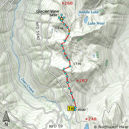
This short but extremely rewarding hike begins at a trailhead along Forest Road 59. Trail #267 follows a ridge of highlands that are just west of Mt Rainier. However, most of the hike is within heavily forested terrain.

In season, there are lots of floral displays along the way. The more open the environment, the better the displays. There is some up and down to this hike. However, each time you climb, you descend less, and eventually gain over 900 feet by the time you reach the summit of Glacier View.

The very name of this peak denotes the expected reward of the hike. Not only do you have a front row seat to Mt Rainier and its awesome glaciers, but you can see Mt Baker to the north, Mt Adams to the southeast, Mt Hood to the south, and Mt St Helens to the southwest.


The following images are random samples of the wildflowers found in the Gifford Pinchot National Forest.
Mouseover image to view flower name, and click on image to jump to flower guide.

Directions:

From Puyallup, WA
From the junction of SR512 and SR161 in Puyallup to the junction of SR161 and SR7 in Elbe is about 36 miles. Then traveling east on SR161 it is about 8 miles to Ashford.

From Morton, WA
Follow SR7 north out of Morton for about 16 miles to the junction of SR161 in Elbe. Turn right onto SR161 and travel about 8 miles east to Ashford.

From Ashford travel east on highway 706 for about 3 miles. Turn left (north) onto Forest Road 59. At 4.1 miles you will pass Forest Road 5920 which goes to the trailhead for Lake Christine. For this hike continue on FR 59 about another 3.8 miles to the trailhead for this hike.


Click on the link below to see a map taking you to the trailhead.

Map Directions


Vicinity Map


To contact the Gifford Pinchot NF for current information: Click Here.


A Virtual Hike in the Gifford Pinchot National Forest
Click for PDF
Click for PDF