

|
THE FOLLOWING MAP IS NOT TO BE USED FOR NAVIGATIONAL PURPOSES.
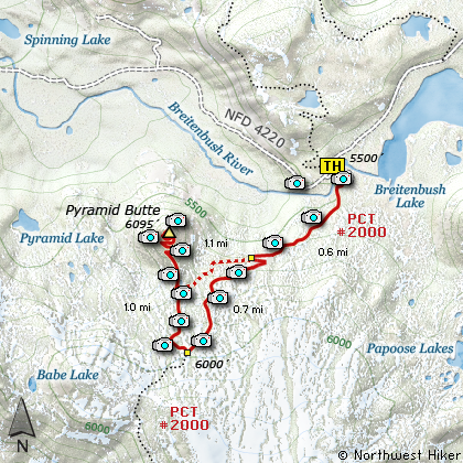
Map of the Pyramid Butte Hike
|
Length: 4 mile loop
Elevation Change: 800' gain
Season: Summer thru Fall
Difficulty: Moderate
Permit: NW Forest Pass Required
Features:
NEW!
Click for PDF Topo Map of this Hike
Be advised that this area was burned in a recent forest fire,
and Pyramid Butte was ravaged.
This hike to Pyramid Butte is in a strange jurisdiction.... it is in the Mt Hood
National Forest, it is in the Mt Jefferson Wilderness, and it is administered by
the Willamette National Forest. Oh well, its in this website because I consider
it to be in the Mt Hood National Forest.
The road to the Pyramid Butte trail head was created in hell.... oops, I said a naughty
word. I apologize, but the road is terrible. HOWEVER, one does not have to take Forest
Road 4220 from Olallie Basin, one can take it from Forest Road 46, which is paved and lined
and a great highway, and only about 15 miles from this trail head. Of course, you do have
to travel Forest Road 4220 from FR46 to get here, but what the hay.... the road isn't all
that bad.... if you own a Sherman Tank or Bradly Fighting Vehicle!!!
So let's hike. The parking area by the way is very nice, toilet and all. You begin the
hike at the south end of the parking area and soon approach another Check Point Charlie.
After you do your duty, the trail begins to climb, gain elevation, go up!!! Actually, for
this hike it's not bad. For those folks heading for Park Ridge, well, that's another story.
Or I should say, that's another website project.
This hike up Pyramid is actually quite simple. About three quarters of a mile into the hike
you will cross a wooden bridge over what can be a vigorous stream. Immediately after the
bridge and behind a large old hemlock, a trail veers off to the right. Actually, I believe
this was the old trail to Jefferson Park, but a new one has been built and it goes straight
ahead. You take the old one. This trail wanders along the hillside with nice views of the
surrounding terrain and meadows. You'll pass a rather spectacular spring just below you
that comes right out of the mountain you're walking on.
Soon you come to the junction of the spur trail that will take you up Pyramid Butte. Now the
folks that made this trail know how to make trails. This steep, but well switch backed trail
takes you right up the mountain with not all that much effort. The trail is neat and the
views are terrific. And when you get to the top, you'll wonder why this butte is visible
in half the universe. It sticks out like a sore thumb from all over the Mt Hood National
Forest. So, when you are here on top, why does it seem so small???? Anyway, it is terrific,
so please enjoy the hike and take lots of pictures and leave only footprints behind.

Pyramid Butte before the forest fire
|
How to get there:
NEW!
Click for PDF Directions Map of this Hike
Follow Highway 224 out of Estacada for
about 26 miles. Right after the bridge
just beyond the Ripplebrook Station,
bear right and continue on Road 46
for another 28 miles. Watch for the
graveled Road 4220 on your left, and take
it for about 10 miles to the trailhead
parking area, complete with toilets.
Note that this road is extremely primitive.
|
|
|
A Virtual Hike of the Mount Hood National Forest


|
|


