

|
THE FOLLOWING MAP IS NOT TO BE USED FOR NAVIGATIONAL PURPOSES.
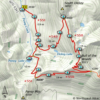
Map of the Bull of the Woods Mountain, Pansy Lake,
Bull of the Woods Wilderness Hike
|
Length: 7.5 miles round trip
Elevation Change: 2090' gain
Season: Late Spring thru Fall
Difficulty: Challenging
Permit: NW Forest Pass Required
Features:
NEW!
Click for PDF Topo Map of this Hike
This is one of the most exceptional hikes in the Bull of the Woods Wilderness. You can
actually make as many hikes out of this one as you'd like to; ie Pansy Lake by itself,
or Bull of the Woods Mtn and back without the loop; or whatever you imagination can
create. For this narrative, I'll be taking you through the loop clockwise.
The trail head begins at Forest Road #6341. You begin a gentle climb through large standing
timber, no doubt old growth. The trail crosses several small streams and is often lined
with the wonderful Rhododendron. At about a mile you come to the junction to Trail #549.
Bear left on this trail and climb a bit more vigorously. You will continue to climb
through a variety of forest environments. About two thirds of a mile up this portion
of the trail you will be able to see Dickey Lake through the trees. There is a user
trail down to the lake if you so desire.
As you continue to climb the trail gets steeper and steeper. A little over a mile and
a quarter on this section of the trail you will intersect Trail #550. Follow this ridge
trail to your right. Now from time to time you will be in the open where you can
enjoy spectacular views. First back down toward your point of origin, then eventually
you will gain the ridge and be able to see back toward Mt Hood. The trail does a couple
of long switchbacks and at each ridge crest you will have excellent views.
In season this part of the trail can have some of the most beautiful floral displays.
The paintbrush and beargrass can be remarkable. The last bit of the trail before
the summit is quite steep but short. When you break out on top of Bull of the Woods
Mountain, you are privileged to some of the best scenery the Mt Hood National Forest
has to offer.
There is still a lookout on top of the mountain. And there is even an outhouse up there.
But most of all there is scenery... and flowers... and did I mention the scenery?
Well, when you eyeballs are full and your camera is spent, continue the loop journey
by following Trail #550 down the mountain ridge until it intersects Trail #558. Bear
a sharp right at this point and continue down the mountain, following a new ridge line
until you meet up with the Pansy Lake Trail #551. This is actually the trail you started
on, its just a few miles further uphill.
Follow the trail to the right and down the mountain toward Pansy Lake. You will encounter
excellent views along the way. Don't be afraid to venture a few feet off the trail to get
some of those extra special photos. After loosing considerable elevation you will come
to the spur trail that takes you to the shore of Pansy Pond.... oops, I mean Pansy Lake.
If you have time, take the trail and enjoy the lake with its wildlife (mosquitos). Of
course they are only there in the spring, summer, and fall, so at least you don't have
to worry about them when you can't even get to the lake due to the snow.
Wander back to the main trail and follow it downhill to the trail head where you began
this memorable adventure.

Fire Lookout on the summit of
Bull of the Woods Mountain
|
How to get there:
NEW!
Click for PDF Directions Map of this Hike
Follow Hwy 224 southeast of Estacada approximately 25 miles until it becomes
Forest Road 46 just after the Ripplebrook Ranger Station and the junction with
Forest Road 57. Continue south for about another 3.7 miles to the junction
with Forest Road 63. Bear right onto FR 63 and cross over the Clackamas River.
The road now follows the Collawash River for approximately 3.5 miles until you
come to the junction with Forest Road 70.
Continue on FR 63 for approximately 2.2 miles and on your right Forest Road 6340
will veer off and uphill. Follow FR 6340 for about 7.8 miles to the junction with
Forest Road 6341. Bear right onto FR 6341, which ironically is paved. Continue
on for about another 3.6 miles and as the road crosses a creek, veering to the right,
you will see the trailhead sign and parking on the right side of the road.
This is the same trailhead for Pansy Lake, Bull of the Woods Mountain, Big Slide Mountain,
Lake Lenore, and Welcome Lakes.
|
|
|
A Virtual Hike of the Mount Hood National Forest


|
|


