

|
THE FOLLOWING MAP IS NOT TO BE USED FOR NAVIGATIONAL PURPOSES.
Map of the Bull of the Woods Wilderness,
Whetstone Mountain, Twin Lakes Hike
|
Length: 16.2 miles round trip
Elevation Change: 2100' cumulative gain
Season: Summer thru Fall
Difficulty: Difficult
Permit: NW Forest Pass Required
Features:
NEW!
Click for PDF Topo Map of this Hike
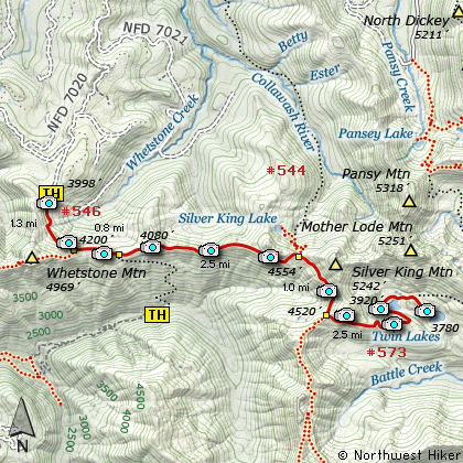
There are many ways to reach the Twin Lakes of the Bull Mtn Wilderness. This narrative
will take you there from the Whetstone Mountain Trail head. The trail drops immediately
after leaving the parking area. You will then pass the wilderness check in spot, complete
with poop-shovels. Then the trails descends through a dense old forest before climbing
back up to the ridge that spans Whetstone Mountain and Silver King Mountain several miles
to the east.
Continue to follow Trail #546 for another 3.3 miles until you come to the junction with
Trail #544. During this part of the hike you will continually gain elevation and loss
it, but each time you go up, you don't go back down quite as far. You hike more and more
in the open and the views just get better and better. In season the flowers are just
fantastic and in the fall the colors are superb. Bear right on Trail #544 and follow
it for the next mile until you come to the junction of Trail #573.
Bear left at this point and follow Trail #573 downhill toward the Twin Lakes. Along
this stretch of the trail you will have excellent views of Battle Ax Mountain to your
southwest and Mt Jefferson to your southeast. As the trail loses elevation, it moves
over the north side of the ridge you are descending. After the last major switchback,
you leave the open areas and enter a tall dense forested area. Nevertheless, soon
you will glimpse the upper Twin Lake through the trees. Finally, you will arrive at
its shore and what a beautiful scene it is. This first view makes the whole hike
worth it.... but there's more.
Continue around the lake and enjoy the lake views as you go. To get to the lower Twin Lake
you follow your trail past the upper lake and just as you dip down a bit to cross a little
stream, you should notice the trail on your right that takes you to the lower lake. This
trail was in very poor condition when I hiked it, but I was able to follow it to the lake
shore. The Lower Twin Lake is a wonderful lake. I'm quite disappointed that the trail
has been let to deteriorate so badly. Nevertheless, you can find it and you can enjoy
the beautiful lake. These two lakes are a real gem and a true reward for your effort.

Battle Ax Mountain as seen from
the Whetstone Mountain Trail
|
How to get there:
NEW!
Click for PDF Directions Map of this Hike
Follow Hwy 224 southeast of Estacada approximately 25 miles until it becomes
Forest Road 46 just after the Ripplebrook Ranger Station and the junction with
Forest Road 57. Continue south for about another 3.7 miles to the junction
with Forest Road 63. Bear right onto FR 63 and cross over the Clackamas River.
The road now follows the Collawash River for approximately 3.5 miles until you
come to the junction with Forest Road 70.
Turn right onto FR 70, which is the same road that takes you the Bagby Hot Springs area.
Continue for approximately 6.5 miles past the Bagby Hot Springs parking area
to the junction with Forest Road 7020. Turn left onto FR 7020 which will take you
steeply up a rather rough road. At times you might think that you are on the wrong
road. Actually, you might wonder if you are on a road... but be assured, it gets
better. It is about 5.5 miles to the trailhead. Just before the trailhead
you will pass the junction to Forest Road 7030, but keep straight ahead.
|
|
|
A Virtual Hike of the Mount Hood National Forest


|
|


