Hike 49
The Mt. Hood National Forest
Jean Lake Hike
Search Northern Hikes Mt Hood Hikes Eastside Hikes Central Hikes Southern Hikes
Home Page
Main Map


Click to view product details

THE FOLLOWING MAP IS NOT TO BE USED FOR NAVIGATIONAL PURPOSES.
Map of the Jean Lake Hike

Length: 1.0 miles round trip
Elevation Change: 265' loss then gain back out
Season: Late Spring thru Late Fall
Difficulty:   Easy
Permit:   NW Forest Pass Required

Features:

NEW!
 Click for PDF Topo Map of this Hike 

This is a short and easy hike. The hike begins to descend almost immediately and drops along the side of a hillside within a dense forest. This short hike brings you to a lovely lake surrounded by timber and a lush meadow. A clear little stream feeds the lake and flowers about in season. The most difficult part of this hike is getting to it. Forest Road 3550 is a challenge at best.


Jean Lake
How to get there:

NEW!
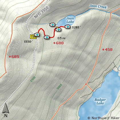
 Click for PDF Directions Map of this Hike 

If you approach this from on Hwy 35 going south out of Hood River, watch for Road 44 to Dufur and points east.
Turn east on Road 44 and follow it for about 3 miles to Road 4410. Turn right on 4410 and follow for about 6 miles. You will come to a junction where you need to bear right on Road 3550. This is a very primitive road, so be aware. Follow this road another 5 miles or so to the trailhead. The trail is on the east side of the road and parking is difficult.

If you are coming from Hwy 26 near Government Camp, and traveling north on Hwy 35, you will need to take the Mt Hood Meadows Ski Resort exit at Bennett Pass. Follow the road behind the sno park area and look for Road 3550. This is a very primitive road so use caution. You will follow this road for about 7 miles to the trailhead. It is on your right. Parking is difficult.


Hike Difficulty Calculator

Calorie Burn Calculator

The 10 Essentials
Bear Encounters

Cougar Encounters

River Crossing Safety
A Virtual Hike of the Mount Hood National Forest


Click to View Instructions
tml>