

|
THE FOLLOWING MAP IS NOT TO BE USED FOR NAVIGATIONAL PURPOSES.
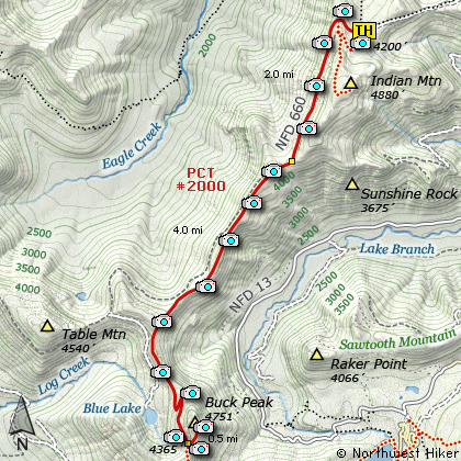
Map of the Buck Peak via Indian Springs Hike
|
Length: 12.5 mi RT
Elevation Change: 1100' gain
Season: Summer thru Fall
Difficulty: Challenging
Permit: NW Forest Pass Not Required
Features:
NEW!
Click for PDF Topo Map of this Hike
This is one of three ways to reach Buck Peak, which by the way is the high point
of Multnomah County (4751'). I do not include in this guide the option of starting at
Lolo Pass and hiking the PCT to Buck Peak. I do include Hike 10
from Lost Lake as an option, and of course the hike on this page from Indian Springs
Campground just south of Wahtum Lake. This hike begins on the PCT at the Indian Springs
Campground and follows the PCT to the base of Buck Peak where you take a short cut-off trail to the summit.
Buck Peak is more popular amongst the county high point hikers than most others,
but it is a great hike and during wildflower season it is even more spectacular.
Because most of the hike uses the Pacific Crest Trail, hiking to Buck Peak from
Indian Springs you are pretty much guaranteed good trail conditions.
The first couple miles of this hike is pretty much out in the open, and the PCT
parallels an old access road that is now mostly overgrown. About two miles into
the hike, the trail crosses the remains of that old road and you don't see it again.
The place where the trail crosses the old road is also the place where the trail
moves from the west side of the divide that it follows to the east side. It is
also the place where the trail pretty much enters a forest for firs, hemlocks,
and cedar, which really limits the views until you actually get to Buck Peak.
About five and a half miles into this hike the trail crosses a spring. Someone
has inserted a pipe into the ground, out of which clean cold water flows. This
is the only water source I noticed on the entire hike. Just a bit further, is
the junction to the cutoff trail that takes you to the summit.
This trail gets very little use, so it can be overgrown at times. But they try
to keep it clear. It is a short hike from here to the summit, and when the weather
cooperates, the views are spectacular.

Looking down on Lost Lake from Buck Peak
|
How to get there:
NEW!
Click for PDF Directions Map of this Hike
These directions take you from Hood River, Oregon.
Whatever direction from which you arrive at Hood River,
follow the sign of old US Hwy 30 into town. From the
west turn right on 13th Street and follow it up the
hill until it merges with 12th. If you are approaching
from the east, on US 30, turn left on 9th and follow it
up the hill until it merges with 12th. Either way,
follow 12th south out of town on what is called
Tucker Road or Hwy 281. About 6 miles out of town you
will cross the Hood River. Immediately after the bridge,
bear right and pass Tucker Park. In about another
six miles you need to bear to the right again following
signs to Lost Lake. This community is referred to as Dee.
As soon as you cross the railroad tracks, bear left and follow the signs to
Lost Lake. This paved road becomes Forest Road 18, and
you need to follow it about another 5 miles. Then
bear right on Forest Road 13 for another 4 miles. Again,
bear right on Forest Road 1310 Forest Road 1310 get a bit narrow in
places, especially where it is exposed to the south.
Be extremely cautious while driving this section of
the road and stay away from the cliff side.
Continue on FR1310 for about another 6 miles to the trailhead parking area
at Wahtum Lake.
At this point, turn left and follow the gravel
road up the hill away from Wahtum Lake. For the next
couple miles, always bear right at junctions. You will
follow this poorly maintained road down a steep hill
and across a saddle then back up to a ridge line. Almost
unnoticed, you will see a poorly maintained road drop
off to the right and down a steep slope. There
you will come upon a very primitive campground called
Indian Springs. The PCT 2000 runs through the camp,
and you can begin your hike to Buck Peak from here.
|
|
|
A Virtual Hike of the Mount Hood National Forest


|
|


