Hike 01
The Mt. Hood National Forest
Mt. Defiance Hike
Search Northern Hikes Mt Hood Hikes Eastside Hikes Central Hikes Southern Hikes
Home Page
Main Map


Click to view product details

THE FOLLOWING MAP IS NOT TO BE USED FOR NAVIGATIONAL PURPOSES.
Map of the Mt Defiance South Approach Hike

Length: 5 miles round trip
Elevation Change: 1138' gain
Season: Late Spring thru Fall
Difficulty:   Moderate
Permit: NW Forest Pass Not Required

Features:

NEW!
 Click for PDF Topo Map of this Hike 

The southern approach to Mt Defiance is quite simple compared to the grueling climb out of the Columbia River Gorge on the north approach. From the trail head it is a short half mile walk through dense forest to the junction to beautiful Bear Lake.

From there on the trail begins to climb more aggressively and soon you begin to enjoy breaks in the dense forest and views of the gorge and mountains to the north. At about two miles the trail junctions with the loop on which you can return if you decide to go completely around Mt Defiance. The trail gets steep yet and more exposed. At the top you are greeted by a huge complex of microwave antennae and relay systems.

Walk pass the structures and follow the road a short distance downhill where you will see the trail continuing its trek down the northeast side of the mountain. Keep alert for the return trail on your left which will take you back up and around the west side to meet up at the junction you saw earlier on your hike. This round the mountain hike is exceptional in its view and seasonal wildflowers.

Return by the same trail you came on once you reach the junction.


Mt. Hood from the Mt. Defiance trail
How to get there:

NEW!
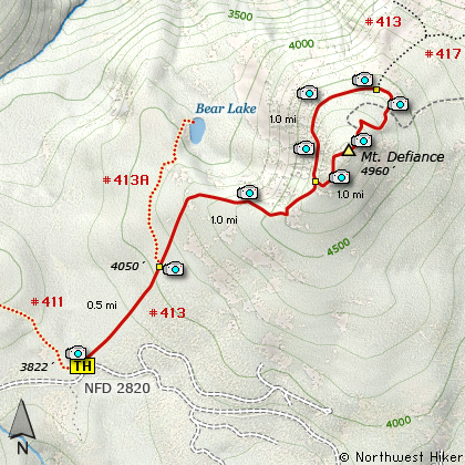
 Click for PDF Directions Map of this Hike 

These directions take you from Hood River, Oregon. Whatever direction from which you arrive at Hood River, follow the sign of old US Hwy 30 into town. From the west turn right on 13th Street and follow it up the hill until it merges with 12th. If you are approaching from the east, on US 30, turn left on 9th and follow it up the hill until it merges with 12th. Either way, follow 12th south out of town on what is called Tucker Road or Hwy 281, which is also referred to as Dee highway. About 6 miles out of town you will cross the Hood River. Immediately after the bridge, bear right and pass Tucker Park. In about another six miles you need to bear to the right again following signs to Lost Lake. However, as soon as you cross the railroad tracks, bear right again and follow signs to Punchbowl Falls. This road renames itself Dead Point Road, which is also Forest Road 2820. Follow FR2820 about 11 miles up to the base of Mt Defiance. The trailhead to Mt. Defiance, Rainy Lake, and North Lake is on your right, parking is on the left.


Hike Difficulty Calculator

Calorie Burn Calculator

The 10 Essentials
Bear Encounters

Cougar Encounters

River Crossing Safety
A Virtual Hike of the Mount Hood National Forest


Click to View Instructions