

|
THE FOLLOWING MAP IS NOT TO BE USED FOR NAVIGATIONAL PURPOSES.
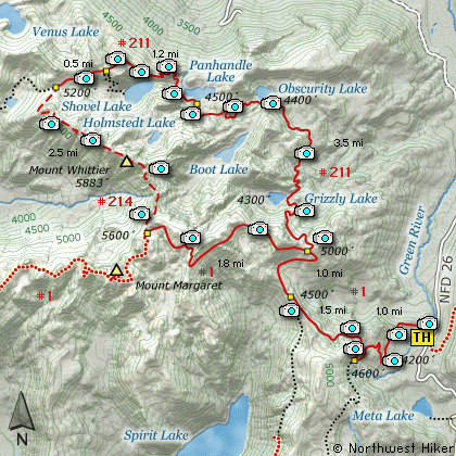
Map of the Mt Margaret Back Country Lakes, Mt Whittier Hike
|
Length: 14.2 Mile Round Trip
Elevation Change: 3630' Cumulative Elevation gain
Season: Mid-Summer thru Fall
Difficulty: Very Difficult - Very Dangerous
Permit: NW Forest Pass Required. If you plan to camp you need a special permit.
Volcano Alert
Call this number to see if this trail is closed:
360-449-7800
ATTENTION:
Please note that this hike description
includes the traverse of the Mt Whittier ridge line. There is NOT a useable
trail along this ridge. Weather and time have destroyed any sense of an
adequate trail in this area. In places there are not safe
ways across steep areas, and therefore the hiker must scramble with no visible
trail. Travel this area entirely at your own risk. Northwest Hiker takes no
responsibility for your safety and does NOT encourage anyone to attempt this
traverse.
Features:
This area referred to as the Mt Margaret Back country is
no doubt the most remote area of the entire Mt St Helens
National Volcanic Monument. This remoteness creates
unique opportunities for solitude and the likelihood of
observing wildlife.
This hike is one of many that begins at the
Norway Pass trail head. You will follow
the same trail as far as the junction to
Trail #211 which takes you over Bear Pass and
down the north side of the Mt Margaret complex.
Upon reaching the junction to Trail #211, turn
and continue climbing to the ridge, which is called
Bear Pass. This ridge is a worthy hike in itself.
From Bear Pass you have excellent views of Mt Rainier
to the north, Mt Adams to the east, Mt Hood to the south,
and of course you are staring into the throat of Mt St Helens.
The trail then descends to Grizzly Lake about a mile below.
Remember, you need a special permit to camp at any of the
lakes in this area. There are designated camp areas which
are the only places you have permission to camp. You must
obtain the permit from the Park Service.
There are many incredible areas to hike and camp on this
northern slope of the Mt Margaret complex. There are a
large variety of wild animals that one can encounter. Pets
are NOT allowed into this area. And if you camp, you must
use extreme caution as to not encourage the local wild life
from partaking of your groceries.
If you decide to make a loop out of this hike and return via
the Mt Whittier ridge line, you must be aware of the inherent dangers
of this back country travel. There once was a trail across Mt Whittier, but
it has long since eroded, collapsed, vanished, disappeared, and otherwise
been abducted by space aliens.
Do NOT try to cross any areas that pose a danger to your being. I
do NOT encourage anyone to hike this ridge. The maps show the trail, so
I am sharing with you what I know about it. I make the trek, so
obviously, it is possible. There are those of you who are a 100
times more skilled than I am, and in far better shape, not to mention
a couple days younger, so it can be done..... by some people.
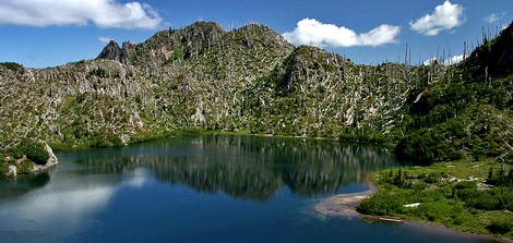
Panhandle Lake
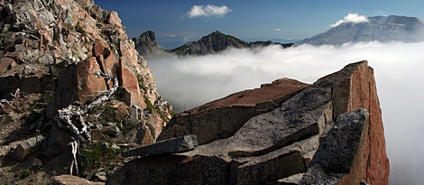
Looking south from Mount Whittier
|
How to get there:
NEW!
Click for PDF Directions Map of this Hike
From Woodland, WA
From Woodland follow SR 503 and the Lewis River
Road for about 48 miles to the community of Cougar, WA. From Cougar, continue
east on the Lewis River Road which will turn into Forest Road 90 after you enter
the Gifford Pinchot National Forest. In about 18.5 miles you will come to the
junction of Forest Road 25. Forest Road 90 makes a right turn, downhill at this
junction, but you will need to continue straight ahead on what is now FR25.
Follow FR25 north for approximately 25 miles, passing the Cedar Flats Natural Area,
and the junction to Forest Road 93, which takes you to the Craggy Peak hike
and the Hat Rock Overlook hike, past Elk Pass and the junction of Forest
Road 28 which leads to the Craggy Peak hike, and finally you will come to
Forest Road 99 on your left, which is the road that leads to the
Windy Ridge side of the Mt. St. Helens National Volcanic Monument and many hikes.
From Carson, WA
If however, you plan to approach this hike from the Columbia River Gorge area, then
begin at Carson, Washington and head northwest on the Wind River Hwy. In 7.5 miles
you will pass through the little community of Stabler, and in another 5.8 miles you
will come to the junction of Forest Road 30. Turn right onto FR30 and follow this
road for 13.2 miles north along the Wind River and then up a steep incline and onto
a plateau where you will come to the junction of the Curly Creek Road. Turn left
onto the Curly Creek Road and follow it downhill past an excellent view area for
about 5.1 miles until you come to Forest Road 90. Turn left onto FR90 and follow
it for about 4.1 miles. You will descent to and cross the Lewis River then come to
the junction with Forest Road 25. Make a sharp right turn onto FR25.
Follow FR25 north for approximately 25 miles, passing the Cedar Flats Natural Area,
and the junction to Forest Road 93, which takes you to the Craggy Peak hike
and the Hat Rock Overlook hike, past Elk Pass and the junction of Forest
Road 28 which leads to the Craggy Peak hike, and finally you will come to
Forest Road 99 on your left, which is the road that leads to the
Windy Ridge side of the Mt. St. Helens National Volcanic Monument and many hikes.
From Randle, WA
Go south out of Randle on SR 131, cross the Cowlitz River, and you will come to
Forest Road 23 on your left. Stay on SR 131 heading south and soon this road
will become Forest Road 25. Continue south on FR25 for almost 20 miles and you
will come to Forest Road 99 on your right.
From junction of FR25 and FR99
After turning onto Forest Road 99, you will climb westward for about 9 miles before
coming to Forest Road 26 on your right, which takes your to the Norway Pass TH, which
is also the parking area for the Mt. Margaret Backcountry hike, which is the Mt. Whittier
traverse.
|
|
|
A Virtual Hike in the Gifford Pinchot National Forest


|
|


