Length: 5.4 Miles round trip
Elevation Change: 1780' Elevation gain
Season: Summer thru Fall
Difficulty: Challenging
Permit: NW Forest Pass Required
Features:
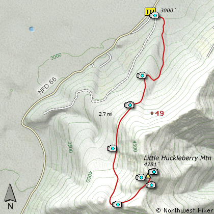
This hike up Little Huckleberry Mountain
begins on a side road off Forest Road
#66. The trail begins in a forested area
and is fairly level for just a couple
hundred yards, then it becomes very steep.
As the trail climbs it wanders in and out
of heavily forested areas and at about
3/4 mile it crosses the ridge line and
enters a densely forested area for most
of the remaining distance.
The trail does do a little up and down
and it makes its way below the rising
ridge line. At nearly 2 miles you will
come to a place referred to as Spring
Camp. Just after this spot, the trail
takes a hard left turn and climbs up onto
the southwest flank of Little Huckleberry
Mountain.
In a short distance the trail breaks out
into the open and remains there for the
rest of the climb to the top. From this
point on you will be able to see many
of the surrounding volcanos, such as
Mt Hood to the south and Mt St Helens to the
west.
When you reach the top you will have great
views of Mt Adams to the northeast and
Mt Rainier to the northwest.
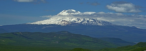
Mt Adams as seen from the summit of Little Huckleberry Mountain
|
How to get there:
NEW!
Click for PDF Directions Map of this Hike
From Portland, travel east on Interstate Hwy 84 to Exit 44 to Cascade Locks.
Exit the freeway and cross over the Columbia River into Washington
via the Bridge of the Gods. Then turn right, or east, and head
east through Stevenson, Washington to the intersection of the Wind
River Highway to Carson, Washington. However, just continue east
on SR14 for another 8.8 miles and you will come to the Cook-Underwood
Road. Turn left onto this road and follow the signs to Willard, WA.
In about 6.7 miles you will drive through the quaint community of Willard.
Continue north and in about a half mile you come to a major junction. Bear
left onto Forest Road 66. Continue on FR66 past many spurs and side roads
for another 12 miles as you skirt a large lava bed to your left. Soon you
will come to what appears to be a side road that parallels FR66. This road
is the parking area for the trailhead to Little Huckleberry Mountain.
From Vancouver, WA travel east on SR14 through Stevenson, Washington to the
intersection of the Wind River Highway to Carson, Washington. However, just
continue east on SR14 for another 8.8 miles and you will come to the Cook-Underwood
Road. Turn left onto this road and follow the signs to Willard, WA.
In about 6.7 miles you will drive through the quaint community of Willard.
Continue north and in about a half mile you come to a major junction. Bear
left onto Forest Road 66. Continue on FR66 past many spurs and side roads
for another 12 miles as you skirt a large lava bed to your left. Soon you
will come to what appears to be a side road that parallels FR66. This road
is the parking area for the trailhead to Little Huckleberry Mountain.
|