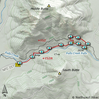
Length: 3.4 Miles round trip
Elevation Change: 600' Elevation gain
Season: Spring thru Fall
Difficulty: Moderate
Permit: NW Forest Pass Required
Features:
This excellent little hike begins
off Forest Road #057. The trail
is gentle and well used. You will
climb a bit at first and then in
about a half mile you will come to
a unique suspension bridge that
spans Falls Creek.
After crossing the creek, the trail
parallels the creek all the way to
the base of the lower falls. There
will be times you can see the creek
as you hike along, but most of the
time you are high enough above it
that you can only hear it. As you
near the end of the trail you will
break out onto a rocky cliff area
where you get great glimpses of the
upper falls.
When you reach the end of the trail
you will be at the base of Falls
Creek Falls. You can see the upper
falls, but not nearly as well as the
lower falls right in front of you.
Note that from December first to April
first the gate allowing access to the
trailhead is closed.
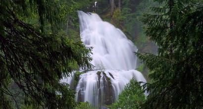
Upper Falls Creek Falls
|
How to get there:
NEW!
Click for PDF Directions Map of this Hike
From Portland, OR
From Portland, travel east on Interstate Hwy 84 to Exit 44 to Cascade Locks.
Exit the freeway and cross over the Columbia River into Washington
via the Bridge of the Gods. Then turn right, or east, and head
east through Stevenson, Washington to the intersection of the Wind
River Highway to Carson, Washington. Bear left onto the Wind River
Highway which will take you through Carson, Washington.
from Vancouver, WA
From Vancouver, WA travel east on SR14 through Stevenson, Washington to the
intersection of the Wind River Highway to Carson, Washington. Bear left onto the
Wind River Highway which will take you through Carson, Washington.
from Carson, WA
Continue north on the Wind River Highway (FR30) for about 8.6 miles to the
little community of Stabler and the junction with Forest Road 43, also called
Hemlock Road. Continue northwest on FR30 for another 5.4 miles and you will
pass a fish hatchery on the left. Continue on another half mile and you
will come to the junction with Forest Road 3065, which continues straight ahead.
Turn right continue north on FR30 for another 0.8 miles and you will
come to Forest Road 3062 on your right. Turn onto FR3062 and follow it another
2.4 miles until you come to a spur off this road on your right numbered FR057.
Turn right onto this spur and follow it a short distance to the parking area
and trailhead for this hike.
|