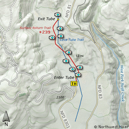
Length: 2.6 Miles round trip
Elevation Change: 400' Elevation gain
Season: Year Round
Difficulty: Moderate due to cave challenges
Permit: NW Forest Pass Required
Volcano Alert
Call this number to see if this trail is closed:
360-449-7800
Features:
Here is one of the most unusual hikes
available in the Gifford Pinchot National Forest.
I will describe the hike as hiking up
a lava tube know as Ape Cave, and
returning via a surface trail.
I must state that this hike is NOT
for everyone.
It has inherent dangers.
This cave is actually a lava tube,
and is one of the longest such in
the world at a length of 12,810 feet.
It is said that the cave was discovered
by members of a youth group known as
the St. Helens Apes. Ape was a word
referring to the mysterious legendary
creature more commonly known as
Sasquatch. It is believed that the
lava tube was formed about 2000 years
ago during the same eruptive event that
caused the phenomenon seen at the
Trail of 2 Forests, Hike #46.
Being a lava tube, Ape Caves
is entered at a point where
you can decide to go uphill to an
exit over a mile away, or go downhill
for a relatively short distance, to
at dead end, thus a need to back
track to your place of origin.
For this description, I will choose
to take the longer more difficult
option. The trail head is located
at a developed parking area off
Forest Road 8303. The trail is
paved to the opening of the cave.
There is a substantial iron stairway
in place to get you into the cave.
You MUST make certain preparations
to do this hike successfully. You
MUST have adequate lighting with you.
Not just one light, but 2. You must
have a backup light, because there
is absolutely NO LIGHT in this cave.
Also, you would be very wise to dress
warmly, as it is always in the 50s
in the cave.... no matter the season.
And by all means where very substantial
footwear. The lava is extremely sharp
and hard.
Upon entering the cave, you will walk
along a iron stairway that takes you
to the bottom of the cave. At that
point you have 2 options. For this
description, I choose the longer,
more difficult hike which heads uphill
for over a mile.
This unique hike up an ancient lava
tube takes you over many piles of
sharp cutting lave boulders. At times
the ceiling will be over 20' above
you and at times you will need to
be careful not to hit your head on
the sharp lava ceiling. These piles
of lava rubble are left over from
when the ceiling collapsed ages ago.
As you make your flash lighted way
up this lava tube, you will face one
major challenge. About 2/3 of the
way up this hike you will come to
an 8 foot wall. Be warned, that
the climb up this wall is NOT EASY.
If you do not feel safe climbing this
wall, then by all means, turn around
and go back the way you came.
In my youth I didn't even consider
this wall a challenge, but now it
seemed very difficult.... but I did
make it.
Eventually you will come to a place
where there is a hole in the ceiling
of this cave. Do NOT under any
circumstances try to exit at this
point. It is only a short walk to
the iron ladder that will take you
out of the lava tube and place you
firmly on the top, where you just
follow the clearly marked path back
to the point where you began this
adventure.
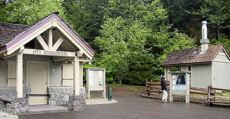
Ranger Station at the Ape Caves
|
How to get there:
NEW!
Click for PDF Directions Map of this Hike
From Woodland, WA
From the junction with I-5 follow SR503 east from Woodland, WA approximately 23
miles to the junction of the Lewis River Road with SR503. Continue east on the
Lewis River Road another 4.4 miles to the junction of Forest Road 81 just before
you get to Cougar. Continue east through Cougar on the Lewis River Road, which
becomes Forest Road 90, for about 7.4 miles to the junction of Forest Roads 90 and 83.
Turn left on FR83. In about 1.7 miles you will come to Forest Road 8303, which leads to the Ape Caves. Turn
left on FR8303 and follow it for about 1 mile to the entrance for the Ape Caves parking area.
|