Length: 10.5 Miles round trip
Elevation Change: 4450' Elevation gain
Season: Late Spring thru Fall
Difficulty: Very Difficult
Permit: NW Forest Pass Required
GPS: N46 8.796, W122 10.974
Latitude: 46.1466
Longitude: -122.1829
Volcano Alert
Call this number to see if this trail is closed:
360-449-7800
Features:
Actually, Mount St Helens can be climbed any
time of year. However, regardless of when
you climb this mountain, you must obtain
a climbing permit. Permits are now available
through the internet.
http://www.mshinstitute.org/explore/climbing-permits/
All 100 permits per day are done online through the Mount St. Helens Institute for a fee.
To register and pay for a pass use this Link.
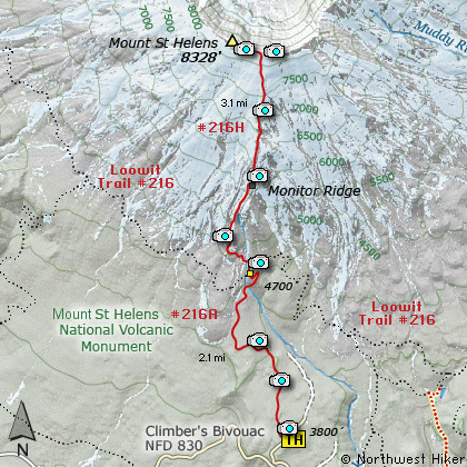
Once you have your permit, drive to the
trail head for the climb at a place called
Climbers Bivouac which is at the end of
Forest Road #830. Depending on the time
of year, the trail to the top of Mount St
Helens can be covered with varying amounts
of snow. I climbed the mountain on July 22,
and never had to walk on snow.
The trail is well marked both in the
forested areas as well as on the mountain
itself. On the mountain the trail is
designated by tall posts. As you begin
the hike/climb you will hike for the
first couple miles in dense forest.
The trail gets increasingly steeper each
step of the way.
At a couple miles you will cross the Loowit
Trail that circles Mount St Helens. There is
a restroom there for your convenience. Then
the trail gets very steep. You remain in
the trees for another half mile or so, then
you break out into the open. At this point
you must find your way to the top of the
mountain by following the pole markers well
placed almost all the way. The trail follow
Monitor Ridge to the top of the mountain.
The steepness is not the most difficult part
of this hike. It seems to me that negotiating
your way through the lava boulders is the greatest
challenge, especially when you are coming down
the mountain. Never the less, this hike is so
very worth it. It just doesn't get any better
than this. There are no technical aspects
of this hike, and yet you end up on top of a
real mountain.
Of course the views are everything.
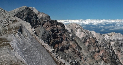
The summit of Mount St Helens
|
How to get there:
NEW!
Click for PDF Directions Map of this Hike
From Woodland, WA
From the junction with I-5 follow SR503 east from Woodland, WA approximately 23
miles to the junction of the Lewis River Road with SR503. Continue east on the
Lewis River Road another 4.4 miles to the junction of Forest Road 81 just before
you get to Cougar. Continue east through Cougar on the Lewis River Road, which
becomes Forest Road 90, for about 7.4 miles to the junction of Forest Roads 90 and 83.
Turn left on FR83. In about 1.7 miles you will pass the road that leads to the Ape Caves,
but continue north on FR83. In another 1.3 miles you will come to the junction to
Forest Road 81. Bear left onto FR81 and after another 1.7 miles you will come to
Forest Road 830 on your right. Bear right and follow FR830 for 2.7 miles to Climber's
Bivouac and the trailhead to climb Mount St. Helens.
|