Length: 10 Miles round trip
Elevation Change: 1770' Elevation gain / 700' loss which you regain on return
Season: Mid-Summer thru Mid-Fall
Difficulty: Challenging
Permit: NW Forest Pass Required
Volcano Alert
Call this number to see if this trail is closed:
360-449-7800
Features:
Now here is a hike that offers it all.
Even though it is relatively steep to
start, most of the hike is along an
outstanding ridge with absolutely
excellent vistas of Mt Rainier, Mt
Adams, Mt Margaret, and Mt St Helens.
In season, this hike is a living
flower garden with more beauty than
the eye can behold.
The hike begins along Forest Road 2612
near Ryan Lake. At first the trail
follows an old logging road, but it
quickly becomes purely a foot trail.
The trail is quite steep during the
first 2 miles as you climb through
dense forest to the ridge of Goat Mountain.
As you reach the ridge, you break out
into more open areas with incredible views.
In season the trail is surrounded by
beautiful floral displays. And no
matter the season, you eyes will wear
out absorbing the views.
The trail follows westward along the south
side of the ridge line of Goat Mountain.
There is a visible users trail to the
top of Goat Mountain, but this CD does
not cover that. As your walk west on
this trail Mt St Helens becomes hidden
by the Mt Margaret formation that lies
between Mt St Helens and the Green River
Valley below you.
As you walk along this portion of the
trail you will see stark evidence of
boundary of the Mt St Helens destruction.
When you arrived on top of the Goat
Mountain ridge you are walking through
an area that never was damaged by the
1980 event. But at about 3 miles, you
walk right out into the open where the
blast forces killed everything.
At about 4 miles, the trail switches
sides of the ridge. Crossing over the
ridge to the north side, you gain
additional vistas to the north and
northeast. As you walk over the
crest of the ridge line, you will
clearly see the terminus of the
Mt St Helens blast zone.
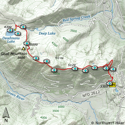
At this point, the trail
begins its descent to Deadmans Lake.
About half way down the ridge, the
trail enters a dense young forest.
You never break out of the forest, until
you are standing on the lake shore. The
east and south sides of the lake have
excellent vistas.
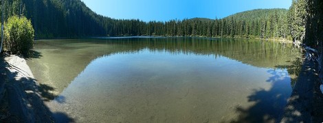
Deadman Lake on Goat Mountain
|
How to get there:
NEW!
Click for PDF Directions Map of this Hike
From Woodland, WA
From Woodland follow SR 503 and the Lewis River
Road for about 48 miles to the community of Cougar, WA. From Cougar, continue
east on the Lewis River Road which will turn into Forest Road 90 after you enter
the Gifford Pinchot National Forest. In about 18.5 miles you will come to the
junction of Forest Road 25. Forest Road 90 makes a right turn, downhill at this
junction, but you will need to continue straight ahead on what is now FR25.
Follow FR25 north for approximately 25 miles, passing the Cedar Flats Natural Area,
and the junction to Forest Road 93, which takes you to the Craggy Peak hike
and the Hat Rock Overlook hike, past Elk Pass and the junction of Forest
Road 28 which leads to the Craggy Peak hike, and finally you will come to
Forest Road 99 on your left, which is the road that leads to the
Windy Ridge side of the Mt. St. Helens National Volcanic Monument and many hikes.
From Carson, WA
If however, you plan to approach this hike from the Columbia River Gorge area, then
begin at Carson, Washington and head northwest on the Wind River Hwy. In 7.5 miles
you will pass through the little community of Stabler, and in another 5.8 miles you
will come to the junction of Forest Road 30. Turn right onto FR30 and follow this
road for 13.2 miles north along the Wind River and then up a steep incline and onto
a plateau where you will come to the junction of the Curly Creek Road. Turn left
onto the Curly Creek Road and follow it downhill past an excellent view area for
about 5.1 miles until you come to Forest Road 90. Turn left onto FR90 and follow
it for about 4.1 miles. You will descent to and cross the Lewis River then come to
the junction with Forest Road 25. Make a sharp right turn onto FR25.
Follow FR25 north for approximately 25 miles, passing the Cedar Flats Natural Area,
and the junction to Forest Road 93, which takes you to the Craggy Peak hike
and the Hat Rock Overlook hike, past Elk Pass and the junction of Forest
Road 28 which leads to the Craggy Peak hike, and finally you will come to
Forest Road 99 on your left, which is the road that leads to the
Windy Ridge side of the Mt. St. Helens National Volcanic Monument and many hikes.
From Randle, WA
Go south out of Randle on SR 131, cross the Cowlitz River, and you will come to
Forest Road 23 on your left. Stay on SR 131 heading south and soon this road
will become Forest Road 25. Continue south on FR25 for almost 20 miles and you
will come to Forest Road 99 on your right.
From junction of FR25 and FR99
After turning onto Forest Road 99, you will climb westward for about 9 miles before
coming to Forest Road 26 on your right, which takes you past the Norway Pass TH and
the Goat Mtn TH. You continue on for a about 3.7 miles and you will pass the spur
road to the Ryan Lake overlook. Just a short distance past this, you will come to
Forest Road 2612 on your left. Turn left onto FR2612 for about a tenth of a mile
and the trailhead to this hike will be on your right.
|