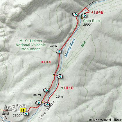
Length: 4 Miles round trip
Elevation Change: 800' Elevation gain/loss
Season: Spring thru Fall
Difficulty: Moderate
Permit: NW Forest Pass Required
Volcano Alert
Call this number to see if this trail is closed:
360-449-7800
Features:
This is one of the most unique hikes
I have ever had the fun of hiking. Lava
Canyon is a relic of the past activity
of Mt St Helens. On this hike you will
clearly see 2 main lava events, one
upon the other. The trail wanders
through this geological phenomenon
in an enjoyable way. There are ladders
to climb and bridges to cross. Use
extreme caution, especially when the
trail is wet, and always stay on the
designated trail.
The trail begins as a Universal Access
Trail for the first 1/2 mile. Then
you will come to a junction. You will
return to this junction via the trail
to the left, but for now, bear right
and follow the trail over a bridge
which spans a narrow section of the
Muddy River. Next you will have to
descend a short steep ladder, and
then a long suspension bridge.
After crossing the suspension bridge,
bear right and follow the trail on
a steep descent into the Muddy River
valley toward Smith Creek. You will
pass several waterfalls and spectacular
cascades. The trail is steep and
narrow in places, so use utmost care.
If the trail is wet, it may be best
to NOT PROCEED.
In about a mile, after crossing a
couple small streams, and descending
a tall steep ladder, you will come to
a junction to Trail #184B. Follow
this trail uphill and up another
short but steep ladder to the top
of Ship Rock. Here you will enjoy
excellent views of Lava Canyon and
several of its waterfalls.
Upon return, when you reach the
suspension bridge, bear right this
time, and instead of crossing the
bridge, follow the trail up to the
junction you passed earlier on your
trip down the canyon. At this point
just follow the UA Trail back to
the trail head.
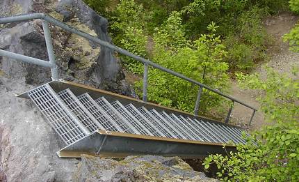
One of many ladders on the Lava Canyon trail
|
How to get there:
NEW!
Click for PDF Directions Map of this Hike
From Woodland, WA
From the junction with I-5 follow SR503 east from Woodland, WA approximately 23
miles to the junction of the Lewis River Road with SR503. Continue east on the
Lewis River Road another 4.4 miles to the junction of Forest Road 81 just before
you get to Cougar. Continue east through Cougar on the Lewis River Road, which
becomes Forest Road 90, for about 7.4 miles to the junction of Forest Roads 90 and 83.
Turn left on FR83. In about 1.7 miles you will pass the road that leads to the Ape Caves, but continue north on FR83.
In another 1.3 miles you will pass the junction to Forest Road 81, but bear right and continue on
FR83. In about 3.8 miles you will pass the parking area for the June Lake hike, but continue on
another 4.3 miles to the parking area for Lava Canyon. Note: You will pass the trailhead for the
Ape Canyon hike just before you reach the parking area for Lava Canyon. Don't confuse them.
|