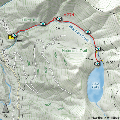
Length: 5 Miles round trip
Elevation Change: 1700' Elevation gain
Season: Summer thru Fall
Difficulty: Challenging
Permit: NW Forest Pass Required
Features:
This hike begins off Forest Road #171 which
is off Forest Road #23. The trail begins an
immediate and very steep climb. The trail
is so steep in places that steps have been
installed to make the climb possible.
The hike begins and remains in a dense
forest most of the time. There are occasional
views during switchbacks and great views
at the very end when you reach Blue Lake.
Blue Lake has a motorized trail to it that
is separate from this trail. You can hike
in peace, but when you get to the lake you
might be greeted with motorbikes.
This hike is very steep, but not all that
long. Much of the hike follows the stream
that comes out of Blue Lake. This offers
fine scenery with small falls and cascades.
Wildflowers are abundant in season.
Just before you reach the lake, you will
cross a bridge over the stream you have been
following only to cross it again at the lake.
When you arrive at the lake there are only a
couple of places where you can easily reach
the water. They are obvious and offer
excellent views.
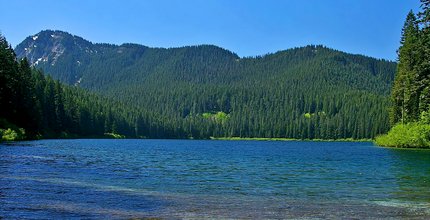
Blue Lake
|
How to get there:
NEW!
Click for PDF Directions Map of this Hike
From I-5 junction with US Hwy 12
Travel east on US Hwy 12 for about 48 miles to Randle.
From Randle, travel south on State Road 131, crossing the Cowlitz River and in a mile
you will come to Cispus Road on your left. Bear left and follow Cispus Road, which become
Forest Road 23, for another 5.2 miles and you will pass Forest Road 55 on your left.
Continue on FR23 for another mile and you will pass Forest Road 083 on your left, which
is the road to Layser Cave. But you keep straight ahead on FR23 for another 1.9 miles.
You will then come to the junction of Forest Road 28. Just continue on FR23 for another
6.7 miles and you will come to Forest Road 171 on your left. Turn left and follow this
steep road about a half mile to the trailhead for Blue Lake.
|