Length: 17 Miles round trip
Elevation Change: 2700' Cumulative Elevation gain
Season: Summer thru Fall
Difficulty: Difficult due to length
Permit: NW Forest Pass Required
Features:
This extraordinary hike begins at the Conrad Meadows parking area at the end of
Forest Road #1000. This meadow is one of the largest continuous meadows in the
country. The first 4 miles of this hike follows the meadow with very little
elevation gain.
The hike begins by following the road for just a couple hundred yards, then
passing an iron gate, the trail sign leads you into the meadow and across a
couple of small streams. In season, the meadow is lush with floral displays.
In season, the meadow is flush with countless mosquitos. In season, the
meadow is alive with large herds of domestic cattle.
Never-the-less, the hike through the meadow is fine and the scenery is great.
After about 4 miles you will enter the Goat Rock Wilderness. The trail then
crosses a fine bridge over Conrad Creek, whose milky color reveals is glacial
origins. The trail then follows the East Fork of the Tieton River for nearly
2 more miles.
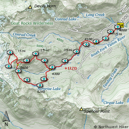
Then you come to the most important junction on the trail. The sign reads the
Surprise Lake Loop Trail #1120, and the arrows point both ways. Either way
you choose will bring you back to this same point in about 5 miles. If you want
to go to Surprise Lake first, bear left. If you want to visit the Conrad Basin
first, bear right.
I followed the trail to the left and headed for Surprise Lake. Soon you will
cross yet another bridge. Immediately after that bridge you finally begin to
climb. And climb you do. You gain about 1200 feet in a little over a mile.
The trail is well maintained and the switchbacks make the climb easy. From
time to time you will have glimpses of the surrounding mountains and valleys.
When you arrive at Surprise Lake, bear to the left and follow a user trail
around the east side of the lake. This allows you the best views of the
mountains to the west, including Curtis Gilbert, the tallest mountain in
the Goat Rock Wilderness.
Return to the trail and continue west. You will enjoy regular views of the
lake as the trails leads to the far west end of the lake. Then the trail
climbs away from the lake as it begins its return journey to the loop fork.
You will pass in and out of alpine meadows, flush with floral displays in
season.
About a mile and a half from Surprise Lake you will come to the junction of
a user trail that takes you up a steep incline to the Conrad Creek Basin.
This short mile climb brings incredible rewards. From mid July thru mid
August the floral displays and glacial views are just fantastic. Continue
up the ridge to Warm Lake if you have the time, or if you are staying over
night.
Return to the main loop trail via the same path that led you to the basin.
Bear left, and follow the trail back to the junction at the bottom of the
hill where you had been earlier on this hike. Then follow the trail you
came in on back to the Conrad Meadows parking area.
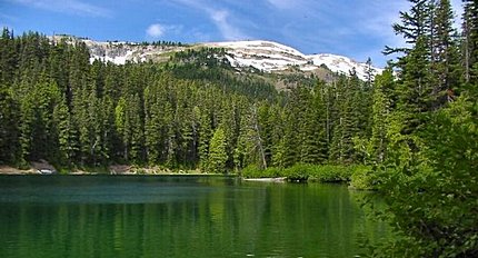
Surprise Lake
|
How to get there:
NEW!
Click for PDF Directions Map of this Hike
From I-5 junction with US Hwy 12
Travel east on US Hwy 12 for about 64 miles to Packwood.
From Packwood travel east on US Hwy 12 for about 28 miles, nearly 7 miles past White Pass,
and you will come to the junction with Forest Road 1200. Turn right onto FR1200 and follow
it around the east end of Rimrock Lake. Follow FR1200 southwest around the far east end
of Rimrock Lake and Clear Lake for about 3.2 miles to the junction of Forest Road 1207.
Bear left staying on FR1200 as it follows the countour of Rimrock Lake along
the southern side of the lake, but climbs high above the lake. Continue east on FR1200
for about 8.2 miles, until you come to the junction with Forest Road 1000.
Bear right, southeast on FR1000 and follow this road all the way to its end (about 12.8 miles),
which will be at Conrad Meadows and the trailhead for this hike.
|