Length: 1.5 mile round trip
Elevation Change: 100' gain
Season: Year Round
Difficulty: Easy
Permit: Pass Not Required
GPS: N45 40.9554, W121 18.039
Latitude: 45.68259
Longitude: -121.30065
Features:
Eastbound on Interstate 84, exit onto US 30 at Exit #69. Follow the Old
Columbia River Highway uphill, winding for about 7 miles.
Westbound from The Dalles on Interstate 84, take Exit #76 at Mayer State Park.
Cross under the freeway and then turn right (west) onto US 30. Wind several
miles uphill to the Rowena Crest Overlook.
You can hike this trail almost any day of the year. Of course,
in the winter that could be a challenge. However, from March
thru October this hike provides you with a wonderful variety
of landscapes to enjoy.
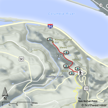
Parking at the Rowena Overlook, or at the Nature Conservancy sign,
walk to the wooden steps that take you over the fence to the trail
that leads downhill toward the Columbia River.
This area is most famous for its spring floral displays. Wildflowers
begin showing themselves as early as late February, and by March are
in full swing. They just keep getting better and better with each
month, until they peak out by the end of June.
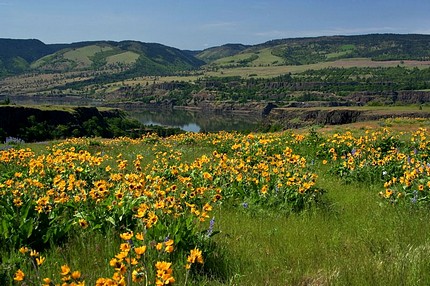 Rowena Plateau
|
|
How to get there:
From I-84 in the Columbia River Gorge, take either the Mosier exit (5 miles east of Hood River) or the Rowena exit (8 miles west of The Dalles).
From Mosier, go east on the Old Scenic Highway (US 30). Beyond milepost 6, the preserve is on both sides of the highway.
Park at the Rowena Crest viewpoint or at the trailhead on Hwy 30.
There are two trails on the preserve.
|