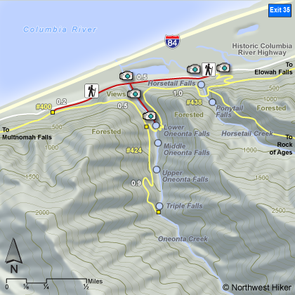
Length: .6 mile round trip up Gorge, 1.5 miles round trip to bridge
Elevation Change: 40' gain
Season: Year Round
Difficulty: Easy
Permit: Pass Not Required
GPS: N45 35.3688, W122 4.5186
Latitude: 45.58948
Longitude: -122.07531
Features:
This popular adventure up Oneonta Gorge is extremely unique. You can visit Oneonta
Gorge any time of year, but you dare only hike up it when the water is very low,
because UNLIKE ANY OTHER HIKE ON THIS WEBSITE, you must actually walk up the river, there
is no trail.... the river is the trail.
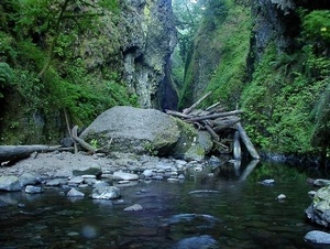
Be aware that the route up this canyon changes continually, and there may be times
when the log-jam near the beginning of the Oneonta canyon is just too difficult to
negotiate. To be safe, you may need to turn back not try and crawl over the logs.
You park in the designated areas near the Oneonta Bridge, and walk down to the water
on the east side of the bridge. After that, you're on your own. Seems precarious,
but it shouldn't be.... thousands do it every year.... and they all survive. Almost
immediately you will come to a large log jam stuck in the canyon. Be VERY CAREFUL
when crossing this, especially if any of it is wet, because it can be very slippery.
After you get across the log jam, now you just walk up the creek.... I mean wade....
in other words.... YOU GET WET.
This is a very short hike, but very soon you are up to your you know what is water.
Yes, it gets deep, and for children, they may not be the ticket, especially for small
children. The water at its lowest is probably about 3 feet deep, so we aren't talking
over anyone's head.... unless anyone is very short. Anyway, after wading this pond,
you come to the end, and the reward that makes it all worth it.... the falls.
After you've taken all the film that's left in your camera, you now have to repeat this
process by wading back out of this hole.... oops, I mean gorge. On a hot summer's day,
hiking doesn't get much better than this. When you finally get back to your vehicle,
and you get dried off and you get dry shoes on your feet, if you'd like, you might
want to go for another short hike and see the top of that canyon you just waddled up.
In recent years a nonprofit group has put together the funds to unearth the Oneonta Tunnel
and make appropriate repairs so that it is close to the original look and safe to walk through.
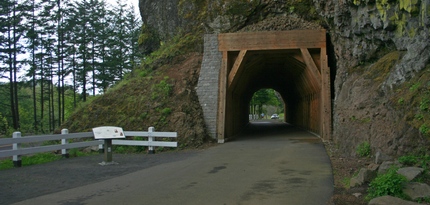 Oneonta Gorge Tunnel
|