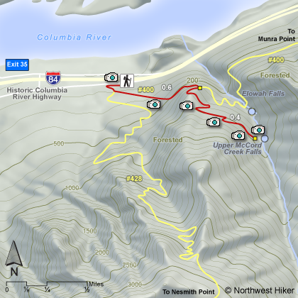
Length: 3 miles RT
Elevation Change: 405' gain
Season: Year Round
Difficulty: Easy
Permit: NW Forest Pass Required
Features:
NEW!
Click for PDF Topo Map of this Hike
This is one of the many true gems in the Great Columbia River Gorge.
Start the hike at the John B Yeon State Park entrance. The trail to Elowah Falls is clearly marked.
After a short walk west, the trail makes an extreme left turn and in just a few feet you will come
to the junction of Trail #400, which heads west toward Nesmith Point, and east toward Elowah Falls.
Go east.
Follow Trail #400 through dense forest as the trail climbs to the junction to
McCord Creek Falls. Bear to your right and follow the trail uphill through a forested
area toward McCord Creek Falls.
After a number of small switchbacks, you will come
out into the open where you begin to enjoy a number of great vistas. Not only do you
have a great view of the Columbia River Gorge, but you can also see the top of Mt Adams
peeking over the northeastern horizon. The trail is cut into the sheer rock wall of this
canyon and has railings for safety.
You will be able to view Elowah Falls from the top
on this trail just before entering a wooded area and coming to McCord Creek Falls. This
double falls is a rare beauty and well worth the hike.
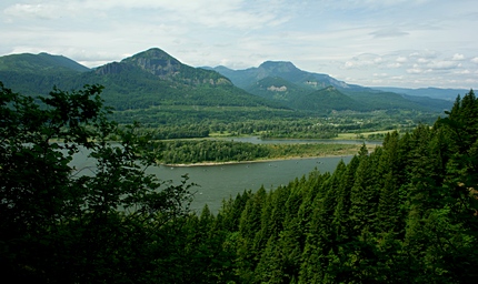 Looking northeast up the Columbia River Gorge
from the McCord Creek Falls trail
|
|
How to get there:
John B Yeon Trailhead: Traveling east on I-84, take Exit #35/Ainsworth. Turn left at the stop sign,
then immediately turn right onto the Frontage Rd. Drive east on Frontage Rd for 2.1 miles and turn
right into the trailhead parking lot. The lot will be just before the road re-enters the highway.
Traveling west on I-84, take Exit #37/Warrendale. Head west on Warrendale Road for about 1/4 mile
to a stop sign. Turn left, go under the freeway and turn left again onto Frontage Rd. Drive 1/4 mile
east to the trailhead parking lot just before the road re-enters the highway.
|