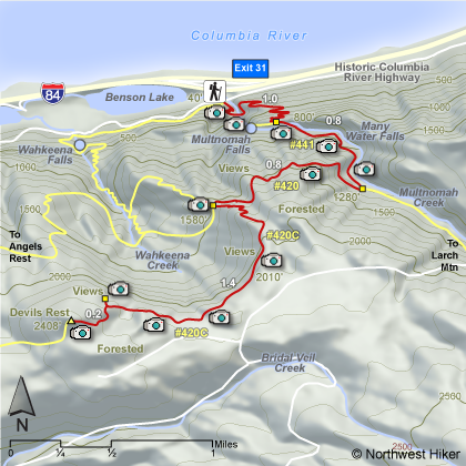
Length: 8.4 miles round trip
Elevation Change: 2368'
Season: Spring thru Fall
Difficulty: Challenging due to steepness of trail and length of hike
Permit: Not Required
Features:
This paved trail takes the hiker across the bridge between the
lower and upper falls, then continues steeply through mostly wooded
areas with occasional views and many switchbacks to the top of the
ridge.
The trail continues downhill for a short distance then after the
turnoff to the view point at the top of Multnomah Falls, the trail becomes
unpaved. There is a large stone bridge across Multnomah Creek, then the
trail begins to climb again but not as steep. After crossing the bridge
there is a junction to the right to the Perdition Trail which has been closed
for several years due to unsafe conditions.
Continue up Trail #441 for about
.8 miles and turn right at the junction to Trail #420. This trail continues
uphill for another .8 miles to the junction to Devil's Rest and Trail #420C.
Make the sharp left turn onto Trail #420C which then climbs steeply through
several switchbacks before leveling off for the next mile. There are several
good views along this part of the hike. The last .2 miles of the hike is in
a dense wooded area and there is no view at the summit.
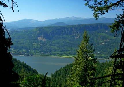 Looking north across the Columbia River Gorge
from a viewpoint along the Devils Rest trail
|
|
How to get there:
From I-84 take Exit #31/Multnomah Falls. Park in the parking lot and walk under
the footbridge to Multnomah Falls Lodge.
Alternatively, take I-84 east to Exit #28/Bridal Veil and drive east on the
Historic Columbia River Highway to the Multnomah Falls Lodge parking area.
Coming from the east on I-84, take exit 35 (Ainsworth Park) and drive about 4 miles west on the
Historic Highway to reach the Multnomah Falls Lodge parking area and trailhead.
From Portland, due to overcrowding at Multnomah Falls in peak season, we highly recommend for convenience and safety, that
you consider using the Gorge Transit bus .
The price is low and the convenience is high.
NEW!
Click for pdf Map of Drections to Multnomah Falls ~ Devil's Rest Hike
|