|
Features:
This another gem of a hike in the Mt. Rainier National Park.
The trailhead for this ambitious hike is located at the Sunrise Point view area.
The trail follows the ridge for a short distance and then drops very
steeply and switchbacks toward Sunrise Lake.
 If you take the spur trail
to Sunrise Lake, you will be glad that you did.
The trail continues for about a miles to climb and descend along its way to Clover Lake.
This is a delightful little lake with a pleasant western shoreline.
If you take the spur trail
to Sunrise Lake, you will be glad that you did.
The trail continues for about a miles to climb and descend along its way to Clover Lake.
This is a delightful little lake with a pleasant western shoreline.
The trail climbs over a ridge as you continue north, and it offers a good
view of the surrounding peaks and valleys. After the trail drops down into
the meadow below, there is a small pond worth walking over to where you
can enjoy great views of the cliffs to the north.
 Again, the trail gently climbs and descends as it works its way north. When you
come to the junction of Hidden Lake, I strongly recommend adding this destination
to your hiking itinerary. When you return to the main trail, continue north past
Dick's Lake. There is a camp area near this small lake.
Again, the trail gently climbs and descends as it works its way north. When you
come to the junction of Hidden Lake, I strongly recommend adding this destination
to your hiking itinerary. When you return to the main trail, continue north past
Dick's Lake. There is a camp area near this small lake.
In another mile you will come to the junction with the trail to Brown Peak. Just a short
distance beyond this junction, you will come to the junction of the trail that will take
you down to Upper Palisades Lake and/or the designated camp area nearby.
In mid-summer, this is a very floral hike. But if you get there too early, you will likely
find snow on the north facing slopes.

Upper Palisades Lake
|


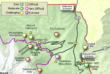


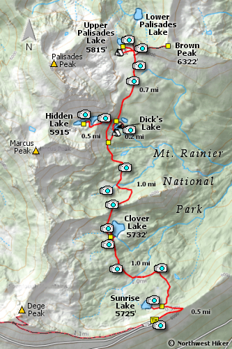


 The Palisades Lakes trail begins at the eastern end of the Sunrise Point Lookout parking area,
which is 10.5 miles from the White Water Entrance to the park.
The Palisades Lakes trail begins at the eastern end of the Sunrise Point Lookout parking area,
which is 10.5 miles from the White Water Entrance to the park.
