|
|
THE FOLLOWING MAP IS NOT TO BE USED FOR NAVIGATIONAL PURPOSES.
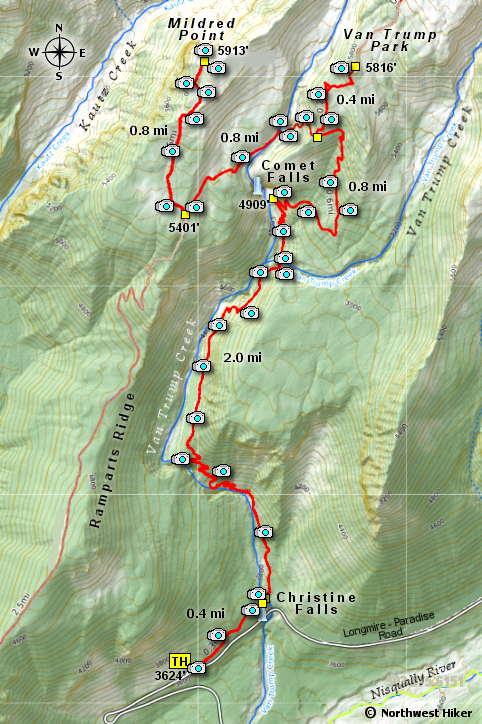 Map of the Van Trump Park and Mildred Point Hike
|
Length: 8 Miles round trip
Elevation Change: 2585' Elevation gain RT
Season: Summer thru Fall
Difficulty: Difficult
Permit: National Park Pass Required
GPS: N46 9.146, W121 6.424
Latitude: 46.9146
Longitude: -121.6424
|
|
How to get there:
It is actually a bit of a challenge to reach the Comet Falls trailhead (which is the same trailhead for Van Trump Park and Mildred Point)
from the north or the east.
From the Yakima, WA area travel on Hwy 12 over White Pass and to the junction
of Washington State Road 123. Turn right (or north) on Hwy 123 and drive to the
toll entrance of the Mt. Rainier National Park. Follow the park roads from there as if
you were going to Longmire. About 4 miles before you get to Longmire, you will come
to the parking area for Comet Falls.
Coming from the northwest follow Hwy 410 from Enumclaw, WA for about 41 miles
to Cyuse Pass, then instead of turning left to Chinook Pass continue straight ahead
until you come to the toll entrance to Mt. Rainier National Park Steven's Canyon
entrance. From this point, just follow the park roads as if you were going to Longmire.
About 4 miles east of Longmire, you will come to the parking area for Comet Falls.
Coming from the southwest follow Washington State Hwy 706 from Ashford and pass
through Longmire. About 4 miles east of Longmire on the highway to Paradise, you will
come to the parking area for Comet Falls.
|
|
|

|


 If you have ever hiked to Comet Falls, the first half of this hike is a repeat
of that adventure.
If you have ever hiked to Comet Falls, the first half of this hike is a repeat
of that adventure.
 I list this hike as difficult due not so much to the distance but to the total
elevation gain of over 2565 feet. The hike consists of a lot of climbing and
descending, only to climb again over and over.... BUT, it is so worth it.
I list this hike as difficult due not so much to the distance but to the total
elevation gain of over 2565 feet. The hike consists of a lot of climbing and
descending, only to climb again over and over.... BUT, it is so worth it.

