|
Features:
This is a very popular hike in the Mt. Rainier National Park because of its
easy access and its modest dimensions. Actually, this presentation is about
two possible hikes, both of which can be accomplished at the same time.
Because of the lower elevation, this hike is snow free early in the summer and
yet provides occasional snow melt ponds along the way. This could increase your
likelihood of encountering mosquitos.
The trail climbs very gently out of the campground area but it gets
steeper as you hike up the Inter Fork valley. The trail is almost completely
within the forest for the first mile, where you will come to the junction for
the trail that crosses the Inter Fork and follows the Emmons Glacier moraine
to the overlook where the maintained trail ends.
 If you choose to return to the campground from this point, you will still have
encountered an absolutely awesome sight. The Emmons Glacier is the largest
glacier in the lower 48 states and it created the very ground that you will
be standing on as its moraine.
If you choose to return to the campground from this point, you will still have
encountered an absolutely awesome sight. The Emmons Glacier is the largest
glacier in the lower 48 states and it created the very ground that you will
be standing on as its moraine.
If you include this hike to the Emmons Glacier overlook, and continue
on to Glacier Basin, then you will add only one additional mile to your activity.
The trail begins to climb much more steeply from this point on. Several small
streams cross the trail and most are bound by rocks which chanel the water
across the trail in a way to avoid erosion.
In about a mile from the intersection to the Emmons Glacier overlook, it will
become obvious to you that this portion of the trail was once a road. The
trail is car wide in several stretches and you climb up out of the valley.
From time to time you will walk past old mining equipment that was abandoned
nearly a century ago when the mining company endeavor was not profitable and
their land was acquired by the national park service.
 At approximately 2.5 miles from the White River campground, you intersect a
trail that leads up Burroughs Mountain and eventrually the Sunrise Visitor Center.
Then in the next mile, the trail climbs steeply to the Glacier Basin camp area.
There is a restroom facility near the camp area and a sign points to its location.
I recommend that you take the trail to the restroom because after passing the
facility, you will come to a small tarn which reflects Mount Rainier and Mount Ruth
in from of it.
At approximately 2.5 miles from the White River campground, you intersect a
trail that leads up Burroughs Mountain and eventrually the Sunrise Visitor Center.
Then in the next mile, the trail climbs steeply to the Glacier Basin camp area.
There is a restroom facility near the camp area and a sign points to its location.
I recommend that you take the trail to the restroom because after passing the
facility, you will come to a small tarn which reflects Mount Rainier and Mount Ruth
in from of it.
Crossing the Inter Fork in order to climb up Mount Ruth ridge, can be a real
challenge. Of course, the time of year that you need to cross the river will
depend on just how difficult it can be. I didn't feel that my life would
be in danger, trying to the cross the rapidly flowing stream, but I was concerned
about slipping and injuring myself.... an ankle, or a leg.
So, if you decide to climb Mount Ruth or just hike up the ridge for a world
class view of Mt. Rainier and the Emmons Glacier, use extreme caution and
good sense.

Mt. Rainier from Mount Ruth ridge
|


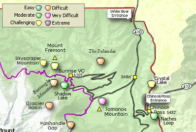


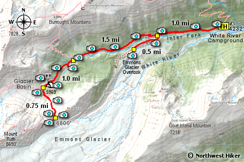


 The trailhead for the Glacier Basin hike is located at the west end of the White River Campground.
