|
|
THE FOLLOWING MAP IS NOT TO BE USED FOR NAVIGATIONAL PURPOSES.
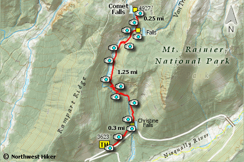 Map of the Comet Falls Hike
|
Length: 3.4 mile RT
Elevation Change: 1293' cumulative elevation gain
Season: Summer thru Fall
Difficulty: Difficult
Permit: National Park Pass Required
GPS: N46 8.752, W121 5.179
Latitude: 46.7787
Longitude: -121.7856
|
|
How to get there:
It is actually a bit of a challenge to reach the Comet Falls trailhead from the north
or the east.
From the Yakima, WA area travel on Hwy 12 over White Pass and to the junction
of Washington State Road 123. Turn right (or north) on Hwy 123 and drive to the
toll entrance of the Mt. Rainier National Park. Follow the park roads from there as if
you were going to Longmire. About 4 miles before you get to Longmire, you will come
to the parking area for Comet Falls.
Coming from the northwest follow Hwy 410 from Enumclaw, WA for about 41 miles
to Cyuse Pass, then instead of turning left to Chinook Pass continue straight ahead
until you come to the toll entrance to Mt. Rainier National Park Steven's Canyon
entrance. From this point, just follow the park roads as if you were going to Longmire.
About 4 miles east of Longmire, you will come to the parking area for Comet Falls.
Coming from the southwest follow Washington State Hwy 706 from Ashford and pass
through Longmire. About 4 miles east of Longmire on the highway to Paradise, you will
come to the parking area for Comet Falls.
|
|
|

|


 You begin this outstanding hike in a steep forested area but the trail soon
levels out to a gentle climb as you approach a sturdy bridge that crosses Van Trump
Creek which is NOT the creek upon which Comet Falls is located. As you cross the bridge
you can look down upon Christine Falls.
You begin this outstanding hike in a steep forested area but the trail soon
levels out to a gentle climb as you approach a sturdy bridge that crosses Van Trump
Creek which is NOT the creek upon which Comet Falls is located. As you cross the bridge
you can look down upon Christine Falls.
 About two-thirds of the way to Comet Falls, the trail climbs an interesting portion of
the trail by an arrangement of log steps. This need not be of concern, but certainly
of interest.
About two-thirds of the way to Comet Falls, the trail climbs an interesting portion of
the trail by an arrangement of log steps. This need not be of concern, but certainly
of interest.

