|
THE FOLLOWING MAP IS NOT TO BE USED FOR NAVIGATIONAL PURPOSES.
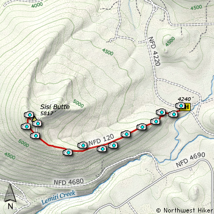
Map of the Sisi Butte Hike
|
Length: 4.2 mi RT
Elevation Change: 1317' gain
Season: Summer thru Fall
Difficulty: Challenging
Permit: NW Forest Pass Not Required
GPS: N44 54.138 W121 47.88
Latitude: 44.9023
Longitude: -121.7980
Features:
NEW!
Click for PDF Topo Map of this Hike
Here is an exceptional, yet easily overlooked hike, because it follows an
access road to a functional fire lookout tower. Sisi Butte is a prominent
shield volcano. Glaciers have carved the northeast flank and left
moraines strung out to the north and east.
Parking is limited, and please don't park in such a way as to block
the roadway in front of the gate. After parking, just hike up the
road to the summit of Sisi Butte.
In season there are a variety of beautiful wildflowers along the
road which add to the joy of this delightful little hike. At first
the road travels in rather dense forest with very few views. But
after about two miles, there are more and more opportunities to
see to the north and the south. If you step off the road on the
south side in more open areas, you can catch exceptional views of
Mt. Jefferson and Olallie Butte.
It is about three miles to the lookout tower on the western peak of Sisi Butte.
There is an eastern summit which is nearly the same elevation. An abandoned
road heads that way before you reach the lookout tower, but it isn't worth
the effort to find the top of the eastern summit. The views and fun are here
on the summit with the tower.
You are welcome to climb to the view area surround the octagon shaped tower.
This structure was built in 1996 and is an active facility in times of
extreme fire danger.

Olallie Butte from Sisi Butte
|
How to get there:
This special little hike is kinda hard to get to as far as traveling decent roads
is concerned. The approach from the north is the best road by far. Drive southeast
out of Estacada on Hwy 224 about 25 miles to the Ripplebrook Ranger Station. Just after
this you cross a bridge as the road bends to the right and is renamed Forest Road 46.
Follow FR 46 another 14.8 miles or so to the junction with Forest Road 42. Take the
left turn onto FR 42 and follow it for about 4.3 miles until it joins Forest Road 4220.
Bear right onto FR 4220 and follow it 2.7 miles to a four way junction. Turn to the
right, which is FR 4220 and follow it about another 1.8 miles to a gated road on your
right. This is the trailhead to Sisi Butte. Park is such a way as to not block this
gated road in any way whatsoever.
|
|
|
A Virtual Hike of the Mount Hood National Forest


|
|