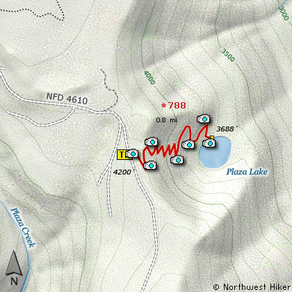
Hike 66
The Mt. Hood National Forest
Plaza Lake Hike
Search Northern Hikes Mt Hood Hikes Eastside Hikes Central Hikes Southern Hikes
Home Page
Main Map


Click to view product details

THE FOLLOWING MAP IS NOT TO BE USED FOR NAVIGATIONAL PURPOSES.
Map of the Plaza Lake Hike

Length: 1.6 mi RT
Elevation Change: 512' loss and regain
Season: Summer thru Fall
Difficulty:    Moderate
Permit: NW Forest Pass Not Required

Features:

NEW!
 Click for PDF Topo Map of this Hike 

If you want solitude, this is the hike for you. First of all, you have to drive into the middle of nowhere, and then you have to hike down a cliff into the middle of nowhere. But once you arrive in the middle of nowhere, I mean at Plaza Lake, you are very likely to have the place all to yourself.... except for a few mosquitos if you manage to get there at the right time of year.

The trail is steep, but not in too bad of shape. The lake shore is difficult to reach, but there are likely fish in this pond for those who might be interested. I'd check the internet or call Fish and Game to be sure, before I went to all the trouble of getting here just to fish.


Plaza Lake
How to get there:

NEW!
 Click for PDF Directions Map of this Hike 

Follow State Highway 224 about 7 miles south of Estacada. Turn north (left) onto Forest Road 4610 (directly across from the Promontory Park recreation area). Follow FR4610 for about 14 miles and you will come upon the trailhead to Tumala Mountain eastern approach (Bald Mtn Trail). Continue another mile or so, and the trailhead to Plaza Lake will be at the end of parking area on your left.


Hike Difficulty Calculator

Calorie Burn Calculator

The 10 Essentials
Bear Encounters

Cougar Encounters

River Crossing Safety
A Virtual Hike of the Mount Hood National Forest


Click to View Instructions