Length: 4 miles round trip
Elevation Change: 1200' gain
Season: Summer thru Fall
Difficulty: Easy
Permit: No Pass Required
Features:
NEW!
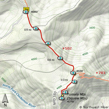
Click for PDF Topo Map of this Hike
Squaw Mountain has been renamed Tumala Mountain.
Here is one of the best kept secrets in the Mt. Hood National Forest.
This little hike is family friendly, and offers some of the best
views of Mt. Hood available for such little effort. Although the
trail begins at a very very steep incline, it only remains that
way for about a quarter mile, then gradually takes you over a
gentle summit and retreats back down a bit before the actual slow
climb to the ridgeline known as Tumala Mountain.
This hike begins at the Old Baldy Trail #502 except you head south
instead of north. After a quarter mile very steep climb through dense
old growth forest, you gentle walk over a low summit then descent
to a saddle where an alternate trail to Tumala Mtn intersects this trail.
Continue south on Trail #502 as the trail climbs steeper and steeper
as it nears a saddle where Trail #783 from the east intersects. At
this point head south along the ridgeline that makes up Tumala Mtn.
You will climb a bit and eventually walk out onto a grave road that
used to be the access to the fire lookout on top of Tumala Mtn. Bear
left and continue uphill just a bit and you will enter a large parking
area. Just look to the left and you will see a couple routes to the
actual ridge where you will be greeted (on a clear day) to one of the
most profound views of the Cascade Mountains.
Walk back and forth to both ends of this ridgeline and you will see
Portland, Oregon off to the northwest, Mt. St. Helens and Mt. Rainier
to the north, and Mt. Adams and Mt. Hood to the northeast. Then as you
look to the southeast, you will see Mt. Jefferson and on a really clear
day you can see Three Fingered Jack, Mt. Washington, and the North Sister.
This easy hike has enormous rewards! Enjoy!

Mt. Hood as seen from the summit of Tumala Mountain
|