

|
THE FOLLOWING MAP IS NOT TO BE USED FOR NAVIGATIONAL PURPOSES.
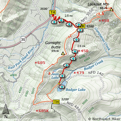
Map of the Badger Lake Hike
|
Length: 5.6 miles round trip from Saddle
Length: 10.6 miles round trip from Hwy 35
Elevation Change: 600' loss then return from Saddle
Elevation Change: 1700' gain then 600' loss then return from Hwy 35
Season: Summer thru Fall
Difficulty: Moderate from Saddle
Difficulty: Challenging from Hwy 35
Permit: NW Forest Pass Required
Features:
NEW!
Click for PDF Topo Map of this Hike
As is obvious, there are a couple of ways to hike to Badger Lake. Because
I've already covered the Gumjuwac Saddle hike on this website (see Hike 50),
I'll write this narrative from Gumjuwac Saddle.
Trail #458 is across the road from where you park and a bit south. Don't get mixed up
with Trail #480, which is a bit to the north of Trail #458. Your Trail #458 climbs for just
a short distance before descending into the valley below. You will be hiking mostly
in a timbered environment. From time to time you will have brief views of the surrounding
areas, but for the most part, you'll be hiking in forest for about the first mile and a half.
At about 1.5 miles, you'll begin the serious descent into Badgerlake Lake. For a while you'll be
hiking in a more open area with some great vistas or the eastern Oregon flatland to the east,
and of Badgerlake Lake itself below you. You will also be able to catch glimpses of Mt Jefferson
peeking over the horizon to the south.
At about 2.6 miles you'll come to the junction of Trails #458 and #479. Just keep straight
ahead and follow the little used Trail #458 to the lake shore. There is an unmaintained
road to Badgerlake Lake, so you'll see vehicles across the lake from where you are. To return
to your vehicle, just reverse your journey and enjoy.

Badger Lake
|
How to get there:
NEW!
Click for PDF Directions Map of this Hike
Whether you approach this from on Hwy 35
going south out of Hood River, or if you
are coming north from Hwy 26 near Government
Camp, watch for the bridge near what was
the Robin Hood Campground.
The trailhead is on the east side of the
road and on the north side of the bridge.
If you desire to begin the hike at
Gumjuwac Saddle, then take Hwy 35
until you come to Road 44.
Turn east on Road 44 and follow it for
about 3 miles to Road 4410. Turn right
on 4410 and follow for about 6 miles.
You will come to a junction where you
need to bear right on Road 3550. This
is a very primitive road, so be aware.
Follow this road another 2 miles or
so to the trailhead. The trail is on
the west side of the road. Parking
is good here.
|
|
|
A Virtual Hike of the Mount Hood National Forest


|
|


