

|
THE FOLLOWING MAP IS NOT TO BE USED FOR NAVIGATIONAL PURPOSES.
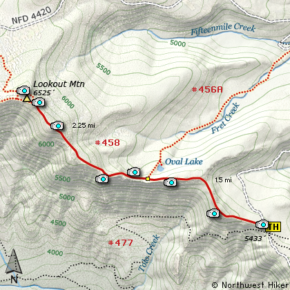
Map of the Lookout Mountain, Divide Trail Hike
|
Length: 7.5 miles round trip
Elevation Change: 1100' gain
Season: Mid Summer thru Fall
Difficulty: Moderate
Permit: NW Forest Pass Required
GPS: N45 19.44, W121 28.59
Latitude: 45.3240
Longitude: -121.4765
Features:
NEW!
Click for PDF Topo Map of this Hike
Now this is the way to climb Lookout Mountain. I mean, there are several ways to climb
the mountain, and this website offers 3 options. But, to me, this is the true Lookout Mtn
climb. You park at a fine trail head and follow a trail designed to take you to the
top of this fine peak. You don't walk on roads (well, maybe the last 100 feet) and
you don't have to piece together other trails to make it work. You just hike and
enjoy the excellent eastern Oregon environment as you ascend this outstanding vista.
The begins in a mountain meadow and for the most part slowly climbs the 1100' feet or
so that you need to reach the summit. There are a couple of steeper parts and just before
the junction to Oval Lake you will descend a bit.... elevation that you need to reclaim
on your way to the top. At about a mile you will begin to walk along cliffy areas that
offer ever expanding views. The higher you climb of course the grander the offering of
vistas. You will be able to see Mt Jefferson to the south and eventually you will have
outstanding views of Mt Adams, Mt Rainier, and Mt St Helens to the north.
But, of course, the main attraction from the top of Lookout Mtn is Mt Hood. This easterly
view presents another of the varied silhouettes of this wondrous peak.

Mt. Adams as seen from the summit of Lookout Mountain
|
How to get there:
NEW!
Click for PDF Directions Map of this Hike
Whether you approach this from on Hwy 35
going south out of Hood River, or if you
are coming north from Hwy 26 near Government
Camp, watch for Road 44 to Dufur and points
east.
Turn east on Road 44 and follow it for
about 6 miles to Road 4420. Turn right
(south) on Road 4420 and follow it for
about 2 miles when it forks with Road 2730.
Follow 2730 for about 2 miles to
Fifteen Mile camp, and about another
mile to the Road 200.
Turn right on Road 200 and follow it
for about 3 miles to the trailhead on
your right. Park here and enjoy.
|
|
|
A Virtual Hike of the Mount Hood National Forest


|
|


