|
THE FOLLOWING MAP IS NOT TO BE USED FOR NAVIGATIONAL PURPOSES.
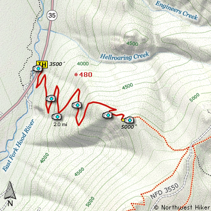
Map of the Gumjuwac Viewpoint Hike
|
Length: 4 miles round trip
Elevation Change: 1500' gain
Season: Late Spring thru Late Fall
Difficulty: Challenging
Permit: NW Forest Pass Required
GPS: N45 20.382, W121 34.212
Latitude: 45.3397
Longitude: -121.5702
Features:
NEW!
Click for PDF Topo Map of this Hike
This is a short but challenging hike. The hike begins to climb almost
immediately and climbs along the side of a steep hillside within a dense forest. About
half way to the viewpoint you get your first glimpse of Mt Hood, mostly visible through
the trees. Then as you round the corner to the viewpoint itself, you begin to enjoy what
made the steep climb worth it. The views of Mt Hood and the valley below are outstanding.
This same trail continues on to Gumjuwac Saddle and then on to Lookout Mountain.
About the name of this hike and saddle.... Gumjuwac. According to the sign at the top
of the saddle, the place is named after a sheppard named Jack, who wore gum shoes. They
supposedly called him gum shoe Jack.... thus Gumjuwac....whatever???
|
How to get there:
NEW!
Click for PDF Directions Map of this Hike
Whether you approach this from on Hwy 35
going south out of Hood River, or if you
are coming north from Hwy 26 near Government
Camp, watch for the bridge near what was
the Robin Hood Campground.
The trailhead is on the east side of the
road and on the north side of the bridge.
|
|
|
A Virtual Hike of the Mount Hood National Forest


|
|