Length: 9.2 miles round trip
Elevation Change: About 2000' cumulative gain
Season: Summer thru late Fall
Difficulty: Challenging
Permit: NW Forest Pass Required
GPS: N45 24.612, W121 36.642
Latitude: 45.4102
Longitude: -121.6107
Features:
NEW!
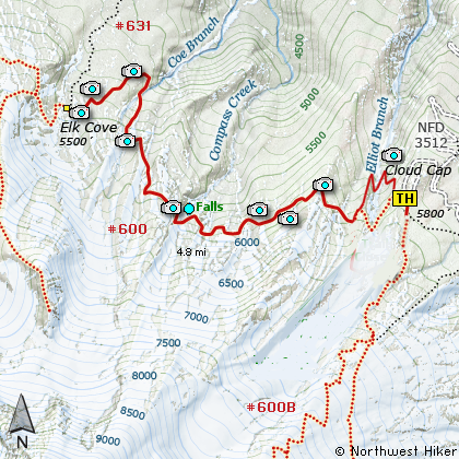
Click for PDF Topo Map of this Hike
First, be aware that the forest service has rerouted the trail across Eliot Creek.
Even though the new trail is excellent, you still have to ford the creek, which is
not easy task.
Did I say Challenging? OK... well, that's an understatement. Note that the elevation
difference between your starting point and destination is only a couple hundred feet.
And the mileage is only 9.2 round trip. Well, stick those numbers in the ol Hike
Difficulty Calculator and see what you get....moderate??? Hummmm, then where do I get
the 2000' feet of elevation gain?? Did I use the word CUMULATIVE? Oh yes, did I
mention that this trail climbs and descends, and climbs and descends, and cli..... oh,
you get the point.
To make matters more interesting, mother Nature has managed to make crossing some of
the streams nearly impossible, so our fine Forest Service has created a detour to help
us survive this adventure. This adds even more up and down to the afore mentioned
2000 feet of elevation gain, so I'd say one really needs to refer to this hike as
Challenging.
I know, enough already, let's talk the hike. OK, so let's say you begin the hike
at the Cloud Cap camp area. At the writing of this narrative, the trail is closed
across Eliot Creek, so one must use the Detour UPHILL and cross the creek where it is
reasonably safe and where the Forest Service has installed a bridge. Follow the
signs and pink ribbons to this safety feature and back to the original trail to
Elk Cove.
Don't be discouraged. This hike is as much fun to make fun of as it is to hike. I
hike this particular hike almost every year and I never get tired of the outstanding
scenery, and I actually enjoy the adventure of wondering just how I'm going to get
across the creeks "this year".
The trail descends gently for several miles through a variety of environments. Sometimes
you are in dense high mountain forests, and other times you are out in the open with
some of the best views in town. On a clear day you can see almost forever. And in
season, the flowers don't get much better anywhere than on this hike to Elk Cove.
About a half mile from your destination, you must cross Coe Creek. Sometimes this is
a difficult challenge. Whatever you do, DO NOT ATTEMPT SOMETHING BEYOND YOU ABILITY LEVEL.
It just isn't worth falling in the creek or injuring yourself. However, I've always
been able to find the right combination of rocks and logs to get across this fast
moving stream.
When you get to Elk Cove, you will consider the effort well worth it. When you get back
to your vehicle at the parking lot at Cloud Cap, you may have different thoughts. Hopefully
not. Hopefully, this hike will be a wonderful adventure filled with all the good stuff
an adventure should have, including a happy ending... and a fun story to share with your
family and friends.

Mt. Hood from the Eliot Glacier moraine crossing
|