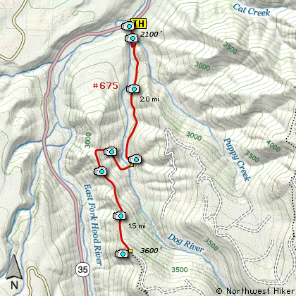
Length: 7 miles round trip
Elevation Change: 1500' gain
Season: Late Spring thru Fall
Difficulty: Challenging
Permit: NW Forest Pass Required
Features:
NEW!
Click for PDF Topo Map of this Hike
This is an outstanding little hike with exceptional rewards. The trail head is
right off state highway 35 and is well marked. The trail itself is kept in
excellent condition and I suspect that is due to the good folks who do mountain
biking on this trail.
This hike never seems challenging, yet the score indicates that it is. You begin
by briefly following an old logging road, then the trail follows the Dog River
for about 2 miles. There are some steep switchbacks right at first, but for the
most part the trail is a gentle climb through a mostly forested terrain.
At a couple miles the trail crosses Dog River on a fine bridge and immediately
begins the steepest of the climbs on this hike. The trail does one long switchback
as it works its way to the ridge. When the trail reaches the ridge line, it does
a sharp left and continues climbing along that ridge.
It is at this point you begin to catch outstanding views of Mt Hood and the river
valley below you. You will also notice highway 35 below you, but it doesn't distract
from the exceptional scenery. At about 3.5 miles into this hike, after a few steep
short switchbacks, you will come to a rock outcropping with the best of views. I
consider this the destination of this hike. Enjoy!

Mt. Hood seen from the East Zig Zag overlook
|