

|
THE FOLLOWING MAP IS NOT TO BE USED FOR NAVIGATIONAL PURPOSES.
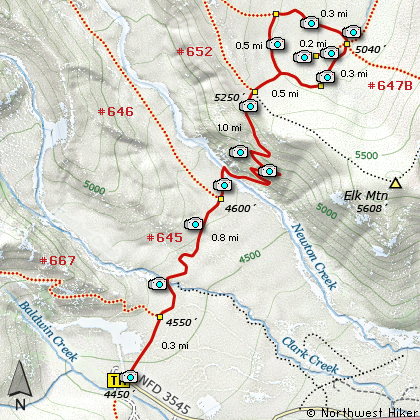
Map of the Elk Meadows Hike
|
Length: 6.2 miles round trip
Elevation Change: 1200' gain
Season: Summer thru Fall
Difficulty: Moderate
Permit: NW Forest Pass Required
Features:
NEW!
Click for PDF Topo Map of this Hike
The Elk Meadows Hike is an enjoyable summer hike with outstanding views and floral displays.
The hike begins near the Mt Hood Meadows Sno Park area and travels level for nearly the first
mile. During this part of the hike you will cross several small streams. As you enter the
Mt Hood Wilderness, you will cross Clark Creek on a fine Forest Service provided bridge.
Then you come to the most difficult part of the hike which is crossing Newton Creek.
The water is fast and depending on the time of year or current weather conditions, the water can
vary greatly in depth. Use caution crossing. After reaching the north side of the
creek, the trail climbs vigorously for about a half mile through a series of 9 switchbacks.
At the top of the ridge, the trail intersects the trail to Bluegrass Ridge #647 and
Gnarl Ridge #652. Continue straight ahead, you will come to Elk Meadows.
When you get to Elk Meadows, you will have to turn left or right and follow the trail
around the meadows. For some reason I always go right. Now you will have outstanding
views of the meadow and of Mt Hood as you circle the meadow on this perimeter trail.
Half way around the meadow you come to the junction of your Trail #645 and Trail 645A,
which you need to follow to complete the loop around the meadow. However, just a few
feet past this junction you can take a small spur trail which goes into the very
center of the meadow. This short walk is worth its weight in gold regardless of the
season.
Upon return to Trail #645A, proceed to your left and follow the trail back to the
point where you arrived at Elk Meadows and retrace your steps back to the trail head
where you began.

Shelter in the middle of Elk Meadows
|
How to get there:
NEW!
Click for PDF Directions Map of this Hike
Follow Oregon Hwy 35 south of Hood River or
north from Hwy 26 near Government Camp until
you come to Road 3545 just a mile or so
north of the turnoff to the Mt Hood Meadows
Ski Resort. Turn on this short
access road for about a half mile and the
trailhead is on the north side along with
the parking space.
Note: This is the same trailhead for the
Mt. Hood Meadows Loop hike, the Elk Meadows hike,
the Newton Creek Loop hike and the Lamberson Butte/Gnarl
Ridge hike.
|
|
|
A Virtual Hike of the Mount Hood National Forest


|
|


