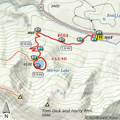
Length: 4.4 mile with loop
Elevation Change: 560 gain
Season: Late Spring thru late summer
Difficulty: Moderate
Permit: Northwest Forest Pass Required May 15 - Oct 1
GPS: N45 18.157, W121 46.644
Latitude: 45.302617
Longitude: -121.7774
Features:
NEW!
Click for PDF Topo Map of this Hike
One of the most popular hikes in the Mt Hood National Forest. This gentle
hike begins at the highway 26 trail head. Most of the hike wanders through dense forest.
There are only a couple areas where you can view the surrounding mountains and valleys until
you reach the lake itself. There is a loop trail that goes around the lake providing
multiple vistas that are exceptional in beauty. Flowers abound during season.

Mirror Lake
|
How to get there:
NEW!
Click for PDF Directions Map of this Hike
Drive US 26 to one mile west of Government Camp
on Mt Hood. The trailhead is on the south side
of the highway. When heading East on US 26 you
turn right off the highway at a sign reading "Ski Bowl West".
The trailhead is immediately on your right upon
exiting the highway.
There is parking for fifty cars at the paved trailhead
completed in 2018. The trailhead also has restroom facilities
which get plenty of use by both hikers and travelers.
Note: This is the trailhead for Mirror Lake
and Tom, Dick and Harry Mountain.
|
|