Hike 13
The Mt. Hood National Forest
Castle Canyon Hike
Search Northern Hikes Mt Hood Hikes Eastside Hikes Central Hikes Southern Hikes
Home Page
Main Map


Click to view product details

THE FOLLOWING MAP IS NOT TO BE USED FOR NAVIGATIONAL PURPOSES.
Map of the Castle Canyon Hike

Length: 1.8 miles round trip
Elevation Change: 800' gain
Season: Early Spring thru Late Fall
Difficulty:   Challenging
Permit:   NW Forest Pass Required

Features:

NEW!
 Click for PDF Topo Map of this Hike 

This is a short but challenging hike. The hike begins to climb almost immediately and climbs along a steep rocky ridge line within a dense forest. Only at the end of the hike do you get great views of the valley and surrounding area.

How to get there:

NEW!
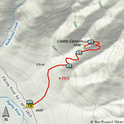
 Click for PDF Directions Map of this Hike 

As you approach Rhododendron on Highway 26 you will cross the bridge over the Zig Zag River. Immediately before entering the town, take a hard left turn onto E. Arlie Mitchell Road. This road points you back westward for about 200 yards, then bears right. After a quarter mile, you will come to a junction with Henry Creek Road and Road 19. Turn left onto the gravel road... Road 19. Follow it for about a half mile. The trailhead is marked and on the right side of the road. Do not park in anyone's driveway.


Hike Difficulty Calculator

Calorie Burn Calculator

The 10 Essentials
Bear Encounters

Cougar Encounters

River Crossing Safety
A Virtual Hike of the Mount Hood National Forest


Click to View Instructions