

|
THE FOLLOWING MAP IS NOT TO BE USED FOR NAVIGATIONAL PURPOSES.
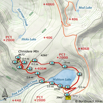
Map of the Chinidere Mountain Hike
|
Length: 4.6 miles round trip
Elevation Change: 230' drop then 943' gain
Season: Early summer thru Fall
Difficulty: Moderate
Permit: NW Forest Pass Required
Features:
NEW!
Click for PDF Topo Map of this Hike
A great family hike that begins at the Wahtum Lake trail head and quickly
descends a couple hundred feet to the Pacific Crest Trail #2000. Turn right and follow this trail around
the lake. The hike gently climbs through dense forest until you reach the junction of the
trail that leads to the summit of Chinidere Mountain. This part of the hike is quite steep
but only about .4 mile in length. The rewarding views from the top are more that worth
the effort to get there.
An alternate route back is to take the Wahtum Lake Cutoff Trail which descends dramatically
to the lake and crosses the outlet stream and reconnects with the PCT #2000. Follow the
trail back to where you first met it, and climb back uphill to the Wahtum Lake trail head.

Looking south toward Mt. Hood from the
summit of Chinidere Mountain
|
How to get there:
NEW!
Click for PDF Directions Map of this Hike
These directions take you from Hood River, Oregon.
Whatever direction from which you arrive at Hood River,
follow the sign of old US Hwy 30 into town. From the
west turn right on 13th Street and follow it up the
hill until it merges with 12th. If you are approaching
from the east, on US 30, turn left on 9th and follow it
up the hill until it merges with 12th. Either way,
follow 12th south out of town on what is called
Tucker Road or Hwy 281. About 6 miles out of town you
will cross the Hood River. Immediately after the bridge,
bear right and pass Tucker Park. In about another
six miles you need to bear to the right again following
signs to Lost Lake. This community is referred to as Dee.
As soon as you cross the railroad tracks, bear left and follow the signs to
Lost Lake. This paved road becomes Forest Road 18, and
you need to follow it about another 5 miles. Then
bear right on Forest Road 13 for another 4 miles. Again,
bear right on Forest Road 1310 Forest Road 1310 get a bit narrow in
places, especially where it is exposed to the south.
Be extremely cautious while driving this section of
the road and stay away from the cliff side.
Continue on FR1310 for about another 6 miles to the trailhead parking area
at Wahtum Lake. This is the trailhead for several hikes.
|
|
|
A Virtual Hike of the Mount Hood National Forest


|
|


