

|
THE FOLLOWING MAP IS NOT TO BE USED FOR NAVIGATIONAL PURPOSES.
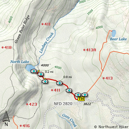
Map of the North Lake Hike
|
Length: 2 miles RT
Elevation Change: 200' gain
Season: Late Spring thru Fall
Difficulty: Easy
Permit: NW Forest Pass Not Required
Features:
NEW!
Click for PDF Topo Map of this Hike
The southern approach to North Lake is quite simple compared to the grueling climb
out of the Columbia River Gorge on the north approach. You begin this hike at
the same trailhead you might use to hike to Mt. Defiance or Bear Lake. But
rather that heading to the east, follow Trail #411 to the west. The trail is
gentle as you climb through a forest of dense fir, hemlock, and cedar.
As you near the lake you will junction with Trail #423 coming from Rainy Lake.
Be careful not to follow Trail #411 to the right and downhill toward the gorge.
Keep straight ahead and in a very short distance you will come to North Lake. A
trail follows along the eastern side of the lake with many exceptional views and
places to rest or picnic.
North Lake is a shallow little lake surrounded by forests and the
cliffs of Green Point Ridge. Nevertheless, it is a gem and well worth the
hike for all ages.

Green Point Ridge rises above North Lake
|
How to get there:
NEW!
Click for PDF Directions Map of this Hike
These directions take you from Hood River, Oregon. Whatever direction from which you arrive at Hood River,
follow the sign of old US Hwy 30 into town. From the west turn right on 13th Street and follow it up the
hill until it merges with 12th. If you are approaching from the east, on US 30, turn left on 9th and follow it
up the hill until it merges with 12th. Either way, follow 12th south out of town on what is called
Tucker Road or Hwy 281, which is also referred to as Dee highway. About 6 miles out of town you will cross the Hood River.
Immediately after the bridge, bear right and pass Tucker Park. In about another six miles you need to bear to the right again following
signs to Lost Lake. However, as soon as you cross the railroad tracks, bear right again and follow signs to
Punchbowl Falls. This road renames itself Dead Point Road, which is also Forest Road 2820. Follow FR2820 about 11 miles
up to the base of Mt Defiance. The trailhead to Mt. Defiance, Rainy Lake, and North Lake is on your right, parking is on the left.
|
|
|
A Virtual Hike of the Mount Hood National Forest


|
|


