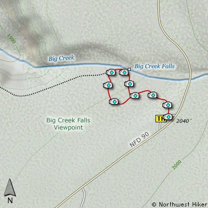
Length: 1/4 mi loop
Elevation Change: Nearly Level
Season: Almost Year Round
Difficulty: Easy
Permit: NW Forest Pass Required
Features:
This is one of the very few universal
access hikes. The loop trail is
gentle and easy to negotiate, for both
the elderly, strollers for the very
young, and wheelchair adventurers.
Big Creek Falls is a breathtaking falls
that drops 110 feet from a rocky cliff
above the Lewis River. There is a
Universal Access Trail about a 1/4
mile long that takes you through a
small grove of Old Growth trees.
|
How to get there:
NEW!
Click for PDF Directions Map of this Hike
From Woodland, WA
From Woodland follow SR 503 and the Lewis River
Road for about 48 miles to the community of Cougar, WA. From Cougar, continue
east on the Lewis River Road which will turn into Forest Road 90 after you enter
the Gifford Pinchot National Forest. In about 18.5 miles you will come to the
junction of Forest Road 25. Turn right and remain on FR90 for another 4.1 miles
and you will pass the junction to the Curly Creek Road. Continue on FR90 for
another mile and you will come to the junction of Forest Road 9039. Continue
on FR90 for another 3.7 miles and you will come to the parking area for this hike.
From Carson, WA
If however, you plan to approach this hike from the Columbia River Gorge area, then
begin at Carson, Washington and head northwest on the Wind River Hwy. In 7.5 miles
you will pass through the little community of Stabler, and in another 5.8 miles you
will come to the junction of Forest Road 30. Turn right onto FR30 and follow this
road for 13.2 miles north along the Wind River and then up a steep incline and onto
a plateau where you will come to the junction of the Curly Creek Road. Turn left
onto the Curly Creek Road and follow it downhill past an excellent view area for
about 5.1 miles until you come to Forest Road 90. Turn right onto FR90 and follow
this road for another mile and you will come to the junction of Forest Road 9039.
Continue on FR90 for another 3.7 miles and you will come to the parking area for this hike.
|