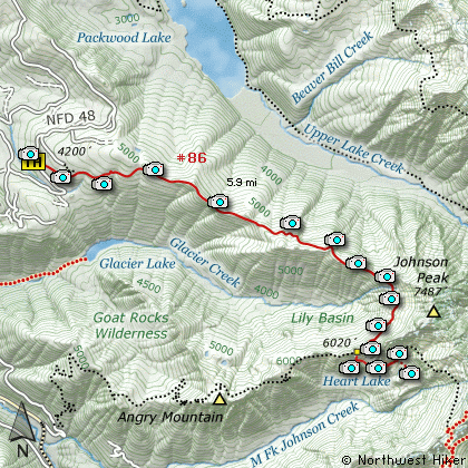
Length: 11.8 Mile Round Trip
Elevation Change: 2000' Elevation Cumulative gain
Season: Mid-Summer thru Fall
Difficulty: Difficult
Permit: No Pass Required
Features:
Here is a gem of a hike that is fairly untraveled.
The trail begins off Forest Road #48 out of Packwood.
There is an alternate route for horses a little
further up Road #48.
The trail climbs a bit through a fairly dense
forested area before converging with the alternate
horse trail. A short while later the trail becomes
more exposed and you can see past the trailside
forest to Angry Mountain and South Point.
Basically, the trail follows a ridgeline, west
to east, toward Johnson Peak. Sometimes the
trail is on the south side of the ridge, and
sometimes it is on the north side.
About half way to the Lily Basin junction to
the Angry Mountain trail, the views to the
north and northwest become more available and
you are able to see Packwood Lake below you
and Mt Rainier to the northwest. Then views
of Johnson Peak become more and more frequent
until the trail actually turns south along the
very base of Johnson Peak.
In early summer this part of the trail can be
very difficult due to the snow filled gullies.
The run-off water creates tunnels beneath the
snow, and the trail crosses over these tunnels.
This can be dangerous, so use great caution.
By the end of July the trail is usually clear
of major snow challenges and the summer floral
display is in full swing. This is why people
hike this trail.... to see the fantastic
wildflower displays in Lily Basin.
After the junction with the Angry Moutain trail,
the Lily Basin trail descends below a large cliffy
area as it makes its way above Heart Lake. There
is a fine trail down to the lake and ample areas
to camp.
One of the extraordinary benefits of hiking this
trail is the high likelihood that you will see
mountain goats. The day I photographed this hike
we say a large herd of over 40 individual goats.
One can scramble up Johnson Peak, but extreme
caution is a must and good footing is a challenge.
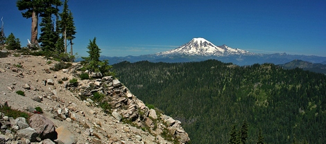
Mt Rainier as seen from the Lily Basin trail
|