Length: 15.8 Miles round trip
Elevation Change: 4150' Cumulative Elevation gain
Season: It is too snowy in the winter and too grown up in the Summer, so do it in the Spring
Difficulty: Very Difficult
Permit: NW Forest Pass Required
Features:
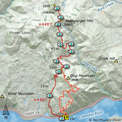
This hike begins at the Dog Mountain
parking area along side State Hwy 14.
Because of the length of this hike,
and because of the cumulative elevation
gain, this is a very difficult hike.
Having said that, I must also emphasize
that this hike is rich with rewards.
The trail starts out in a steep climb
which it never really moderates until
it reaches the saddle on the western
flank of Dog Mountain. The trail
wanders in and out of heavily forested
areas, affording you many significant
views of the Columbia River Gorge and
surround terrain.
In season this hike is extremely floral
for which Dog Mountain is famous. Well,
Augspurger is also extremely floral in
the late spring, and this is much of the
reward for climbing it.
After about 2.8 miles you will come to
the junction of the Dog Mountain Trail.
Keep straight ahead and descend on the
Augspurger Mtn trail into a small valley.
You will loose about 400 feet in elevation,
that you will have to reclaim on your way
back. There is another section of trail
like this at the very end of the hike.
As you follow this trail down the mountain
and cross a small valley, the trail then
begins to follow an old roadbed. This will
take you uphill and under a major power line.
Just keep straight ahead. Continue to follow
the roadbed trail until you come to the first
major corner. Here you will see the trail
take off into the forest. Follow it.
In a ways the trail will begin to curve to
the west then climb up the side of a ridge.
It will then curve back to the right and
out into the open. From here on you will
be able to enjoy a variety of views as you
continue to climb Augspurger Mountain.
In season the floral displays along this
part of the trail are as good as they get.
The first half of June is a perfect time
to hike this mountain and enjoy all the
many floral bouquets. As you climb up this
ridge line, you will soon be looking down
on the power lines that you hiked under a
ways back.
The trail gets steeper as it nears the
summit, and the views south toward Mt Hood
just get better and better. There are
times when the trail wanders into the
forest, but it is often out in the open.
When you reach the highest ridge line, the
trail follows that up to the densely
forested top of Augspurger Mountain.
If you follow the trail to the left,
you will find yourself descending onto
another ridge to the northwest of the
main mountain. If you follow this
ridge trail you will treated to exception
views of the Columbia River Gorge,
Mt St Helens, Mt Rainier, and Mt Adams.
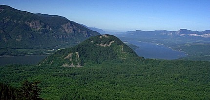
Wind Mountain as seen from the Augspurger trail
|
How to get there:
NEW!
Click for PDF Directions Map of this Hike
From Portland, travel east on Interstate Hwy 84 to Exit 44 to Cascade Locks.
Exit the freeway and cross over the Columbia River into Washington
via the Bridge of the Gods. Then turn right, or east, and head
east through Stevenson, Washington to the intersection of the Wind
River Highway to Carson, Washington. However, just continue east
on SR14 for another 6.2 miles and you will come to the large parking
area and trailheads for both the Dog Mountain and Augspurger Mountain hikes.
From Vancouver, WA travel east on SR14 through Stevenson, Washington to the
intersection of the Wind River Highway to Carson, Washington. However, just
continue east on SR14 for another 6.2 miles and you will come to the large parking
area and trailheads for both the Dog Mountain and Augspurger Mountain hikes.
From either direction, due to overcrowding at the Dog Mountain trailhead in peak season, we highly recommend for safety that
you consider using the Skamania County Gorge West End Transit bus .
The price is low and the convenience is high.
|